Share this @internewscast.com
Intense rainfall continues to drench the northeastern tropical coastline, with a severe weather alert remaining active today.
Between Townsville and Bowen, coastal regions anticipate receiving 100 to 200mm of rain, with even greater amounts possible along the coastal fringe extending up to Cairns.

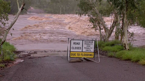
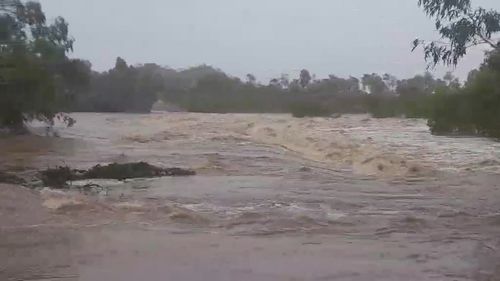
The Bureau of Meteorology has warned that this heavy rainfall may lead to further flash flooding, as waterways are already swollen from recent downpours.
“Heavy rain persists across northern Queensland,” stated Jonathan How, meteorologist at the Bureau of Meteorology.
“Although the rain is expected to taper off later today into tomorrow, we remind Queenslanders that these heavy showers can still cause flash flooding and lead to rising river levels.”
The rainfall is projected to ease by the afternoon, only to intensify again this evening along the coast between Rollingstone and Ayr.
Flood warnings are also current for the Mulgrave, Russell, Tully, Murray, Cloncurry and Georgina catchments.
Water levels along the Leichhardt River peaked near 16.25 metres at Lorraine on Tuesday, causing major flooding.
The main flood peak is now approaching Floraville, where river levels are expected to continue rising in the coming days. 
Moderate flooding is likely at Normanton, in the state’s north-west, where river levels at Glenore Weir are just above 12 metres and slowly rising.
Thankfully, a weather warning for heavy rain across the north-west of the state, including the Northern Goldfields, Upper Flinders, North West and Central West districts, has been cancelled after conditions eased.
Residents in Winton and Corfield could be hit by severe thunderstorms in the coming hours.
Record rainfalls across North Tropical Coast
Rainfall topped a metre at three locations on Queensland’s North Tropical coast yesterday.
Bingil Bay was hit with a deluge of 1114.2mm over the last four days, while South Mission Beach and Cowley beach each received nearly 1050mm in the same period.
By comparison, Brisbane’s annual rainfall is just over a metre, according to WeatherZone.
Parts of Queensland’s North Tropical Coast could see a further 400 to 800mm by the start of next week, which could potentially take totals from this event close to two metres of rainfall.

Record-breaking rain also fell inland in Queensland’s Gulf Country, North West, and Northern Goldfields and Upper Flinders forecast districts
Major flooding is expected to continue along many waterways in the north, including the Herbert, Bohle, Flinders, Nicholson, Leichhardt, Norman, Gilbert, Western and Diamantina Rivers.
Premier David Crisafulli announced disaster relief for the affected areas earlier this week.