
Share this @internewscast.com
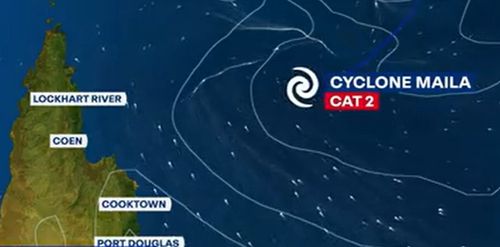
Severe Tropical Cyclone Maila has regained momentum today, advancing once more on a trajectory towards Far North Queensland.
Positioned approximately 1300 kilometers off Australia’s coastline, the cyclone is anticipated to gradually shift southwest in the days ahead.
According to the Bureau of Meteorology, the category four cyclone, with wind gusts reaching up to 260 kilometers per hour, is projected to make landfall early next week.
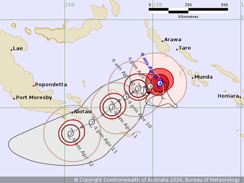
After experiencing a temporary halt between Papua New Guinea and the Solomon Islands yesterday, forecasters now report that the cyclone is progressing at a speed of about 10 kilometers per hour towards Queensland.
Senior meteorologist Jonathan How indicated, “The cyclone is expected to approach the Far North Queensland coast by Sunday into Monday morning, with growing confidence it will advance towards Cape York.”
How mentioned that current predictions suggest the cyclone could make landfall either late Monday or early Tuesday.
It is forecast to decline to at least a category three cyclone before then.
The weather system is expected to impact a large area of Far North Queensland between Cooktown and the Lockhart River shire, which was struck by Tropical Cyclone Narelle last month.
“Communities in these areas could see further damaging to destructive winds as well as heavy rainfall and flooding and coastal erosion,” How said.
Meanwhile, a second storm, currently a tropical low, is forming in the Indian ocean off to the north-west of Western Australia and Fiji.
The Bureau rates it a moderate chance to attain cyclone status from mid-next week.
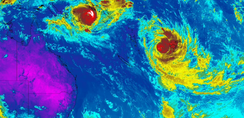
A third weather system, Tropical Cyclone Vaianu, is continuing to move southwards today, the Fiji Meteorological Service said.
It is roughly halfway between Fiji and New Zealand with winds of 95km/h near the centre.
It is expected to make landfall on Sunday.
NEVER MISS A STORY: Get your breaking news and exclusive stories first by following us across all platforms.