Share this @internewscast.com

In brief
- Severe Tropical Cyclone Maila is forecast to slowly turn towards far north Queensland on Thursday.
- It had stalled between the Solomon Islands and Papua New Guinea for several days.
A historic cyclone is poised to finally advance toward the Australian coastline, raising concerns for a region already weary from flooding.
Severe Tropical Cyclone Maila is expected to begin its slow approach to far north Queensland on Thursday, after lingering between the Solomon Islands and Papua New Guinea for several days.
This formidable category 4 cyclone is currently unleashing wind gusts reaching 260 km/h, having set a new record as the most powerful cyclone documented so far north in the Solomon Sea.
As it encounters land near Papua New Guinea, Maila is predicted to weaken, eventually making a gradual advance toward Queensland’s coast, with a potential landfall anticipated next week.
Communities in far north Queensland remain cautious about the storm’s potential effects, as its projected path mirrors that of Cyclone Narelle, which struck the region in March.
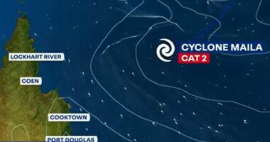
According to Jonathan How from the Bureau of Meteorology, Maila is expected to make landfall between Cooktown and Lockhart River on Tuesday as a category 2 cyclone.
“There is still some variation in the exact timing among the computer models, but confidence is increasing that Maila’s track will take it towards northern parts of Cape York peninsula,” he said.
“But it is still five days away, and Maila’s exact path, timing and strength will be influenced by a number of factors before then.”
Maila is on track to cross close to where Narelle hit Cape York on 20 March before it left a trail of damage across the Top End and Western Australia.
It regained strength after crossing northern Australia and slammed into WA’s north-west, peaking as a category 4 system as it destroyed buildings, brought down trees and triggered flooding.
On Thursday, the weather bureau warned that Cape York communities could expect further damaging to destructive winds, potentially intense rainfall, flooding and coastal erosion upon Maila’s arrival.
Another cyclone would be a blow to a region still cleaning up Narelle’s mess.
Maila was at one stage rated a category 5 system before it resumed its slow march toward Australia.
Maila’s location at sea has so far kept the most damaging winds away from major population centres.
Footage showed destruction of property in remote parts of the Solomon Islands’ Western and Choiseul provinces.
National broadcaster SIBC reported that three members of one family had gone missing after a boat capsized in heavy seas.
BoM senior meteorologist Liam Smart told AAP Maila was a record-setter for the region.
“It’s the strongest cyclone this far north in the Solomon Sea on record,” he said.
While it is technically possible for cyclones — known in the northern hemisphere as hurricanes or typhoons — to form at just one degree north or south of the equator, it is exceedingly rare.
For the latest from SBS News, download our app and subscribe to our newsletter.