
Share this @internewscast.com
According to the bureau, “Hayley has likely reached its maximum intensity and is expected to start diminishing in strength today before making landfall.”

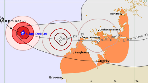
Despite the weakening trend, the cyclone is projected to maintain category three intensity as it approaches land.
Currently, the system is positioned 240 kilometers west of Cape Leveque and 255 kilometers northwest of Broome, exhibiting sustained winds near the center at 165 km/h and gusts reaching up to 230 km/h.
The warning area now spans from north of Broome to Kuri Bay, encompassing regions such as the Dampier Peninsula and Derby.
The bureau has indicated that destructive wind gusts, reaching speeds of up to 170 km/h, could impact the northern Dampier Peninsula, including areas like Beagle Bay and Cape Leveque, starting early this afternoon.
These powerful winds might also extend to Cockatoo Island later in the evening or by tomorrow morning.
Heavy rainfall which may lead to flash flooding is possible near the track for the area under the warning from today.