
Share this @internewscast.com
Heavy rain which could bring flooding, strong winds and large surf is set to hit Australia’s east coast next week.
The cold weather system is expected to produce strong winds reaching speeds of up to 100 km/h, according to meteorologists, while areas could experience up to 300 mm of rain, leading to possible flooding.
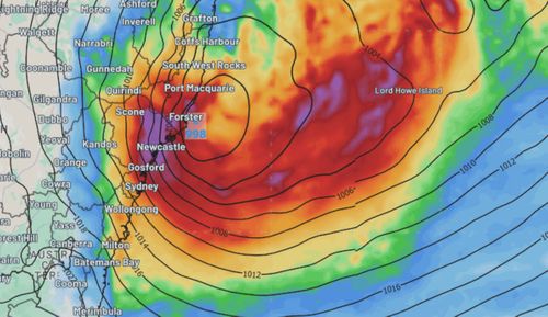
Weatherzone experts stated, “Showers alongside strong winds may escalate into intense and potentially flood-inducing rain, with damaging gusts as the system possibly forms into an East Coast Low (ECL) near the NSW shoreline on Tuesday, July 1.”
“Regions such as the Mid North Coast and Hunter might see rainfall between 100-200 mm over a span of 36 to 48 hours up until Thursday next week, and these conditions could extend southward to the South Coast.”
“The deep feed of moisture coming off the Tasman Sea could interact with local topography around the Mid North Coast, Hunter and Central Coast, with rainfall totals reaching 300mm possible in some parts.”
Waves of up to 13 metres are possible, it warned, with coastal erosion likely.
However, they say it’s unclear how it will develop.
Rain is forecast in NSW from Monday afternoon until Thursday, the BOM reports.
It will get up to 17C in the day, with the sun set to return on Friday,
Other east coast lows which have smashed the coast have brought erosion to parts of Sydney’s Northern Beaches and the NSW Central Coast.
It once snowed in Sydney on this day
While Sydney is sunny with temperatures of between 18 C and a low of 6C overnight, it did once snow on this day.
In 1836, newspapers reported “the first snow storm ever known in Sydney.”
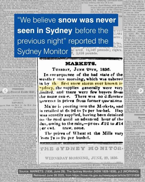
According to a post on Instagram from City of Sydney, newspapers reported temperatures of just 3C.
It noted supplies were limited at markets because of the weather.

Stalled car sends the world to war
Weather forecast around Australia
Melbourne can expect showers from Sunday and into the week, with temperatures between 5C and 13 C.
Canberra can expect a chilly overnight temperature of -6 on Sunday, with highs of 13C.
Showers will clear by Monday in Adelaide which will get up to 16C.
Brisbane is also set for showers into the week, as is Perth.
Cairns will have a wet weekend but will be a warm 26C.
Hobart will be mainly sunny once showers ease on Sunday.