Share this @internewscast.com
Flash flooding slammed parts of Wisconsin on Saturday evening, forcing an airport to close and left residents trapped inside their homes.
Heavy rain pummeled the Badger State, prompting the National Weather Service (NWS) to issue a flash flood warning for Milwaukee, West Allis, and Wauwatosa.
Photos showed rising floodwaters submerging cars, including a video clip where a man is seen stranded on a car hood as swift currents flow by.
Other videos shared online show streets in the state flooded with rainfall totals exceeding six inches in some parts of the state, the NWS said.
Reports indicated that residents near the Menomonee River were trapped in their homes early Sunday morning due to severe flooding in the area.
Mitchell International Airport said just after 3 AM on Sunday morning that all of their runways bar one was flooded.
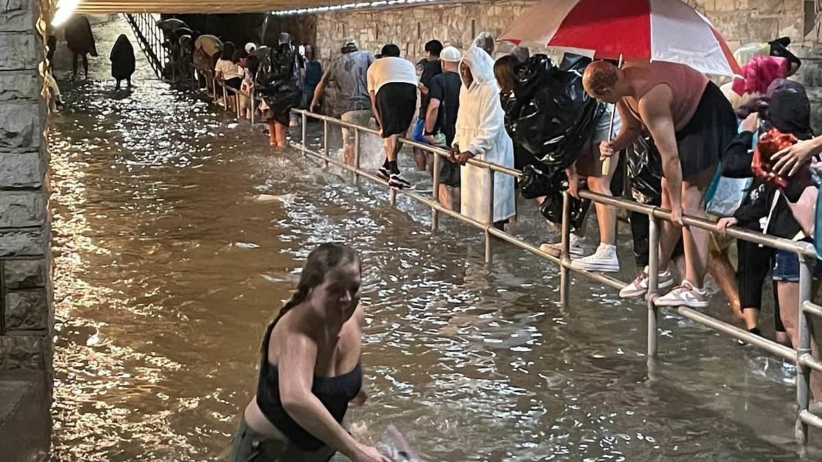
The brutal storms also forced the Wisconsin State Fair to close early and cancel their main stage performance, Lynyrd Skynyrd.
Videos from the fairgrounds revealed the significant flooding during the event, with attendees wading through deep water toward the nearest exits.

Locals can be seen here fleeing from the Wisconsin State Fair after flash flooding swamped the area

Images emerged of flood waters rising over cars in the state, in one clip a man is seen stranded sitting on the hood of a car
TMJ4 also shared video footage they had of vehicles trapped in the flood waters at the fair.
Fair officials announced the closure shortly before 10PM, saying: ‘Attention Fairgoers! The State Fair Park is closing.
‘Please be cautious as you head to the nearest exit safely and adhere to the directions of Fair Park staff and police as you leave.’
According to the We Energies outage map, around 45,000 customers were without electricity as of Sunday morning.
According to the Milwaukee Journal Sentinel, the highest rain total was 10 inches in Butler.
Rain monitors ran by Milwaukee Metropolitan Sewerage District said that over 13 inches had fallen in the 8100 block of W. Florist Ave in Milwaukee.
The outlet also reported that streets and creeks were flooded in Milwaukee, with some basements also underwater.
Benjamin Sheppard, a meteorologist at the NWS office in Milwaukee, said that those in the city should expect more to come.

Other videos shared online show streets in the state flooded with rainfall totals exceeding six inches in some parts of the state

According to the We Energies outage map, around 45,000 customers were without electricity as of Sunday morning

The NWS urges anyone caught in a flash flood to ‘turn around, don’t drown’ and to avoid getting in a car
He stated: ‘The first wave of storms today has been somewhat unpredictable regarding when and where they’ll strengthen and how quickly they will advance and move.’
The heaviest of the downpours are expected to land on Sunday night. Sheppard added that some fallen trees had been reported in Menomonee Falls.
In their latest warning for parts of Wisconsin, issued on Sunday morning, they said: ‘At 619 AM CDT, Doppler radar indicated thunderstorms producing heavy rain across the warned area.
‘Between 3 and 4 inches of rain have fallen. Muscoda and Boscobel had received over 3 inches of rain as of 615 am.
‘Additional rainfall amounts of 1 to 3 inches are possible in the warned area. Flash flooding is ongoing or expected to begin shortly.’
The NWS urges anyone caught in a flash flood to ‘turn around, don`t drown when encountering flooded roads. Most flood deaths occur in vehicles’, they said.