
Share this @internewscast.com
A tropical rainstorm in the Atlantic Ocean is predicted to develop into the first hurricane of the 2025 season this week.
AccuWeather meteorologists have predicted that the system might soon be named Erin, with a chance of reaching hurricane status by August 14, and potentially escalating to a Category 3 hurricane by August 16.
Senior meteorologist Chad Merrill noted, ‘Several elements are in its favor, such as the absence of dust, the presence of warm waters, and minimal disruptive winds.’
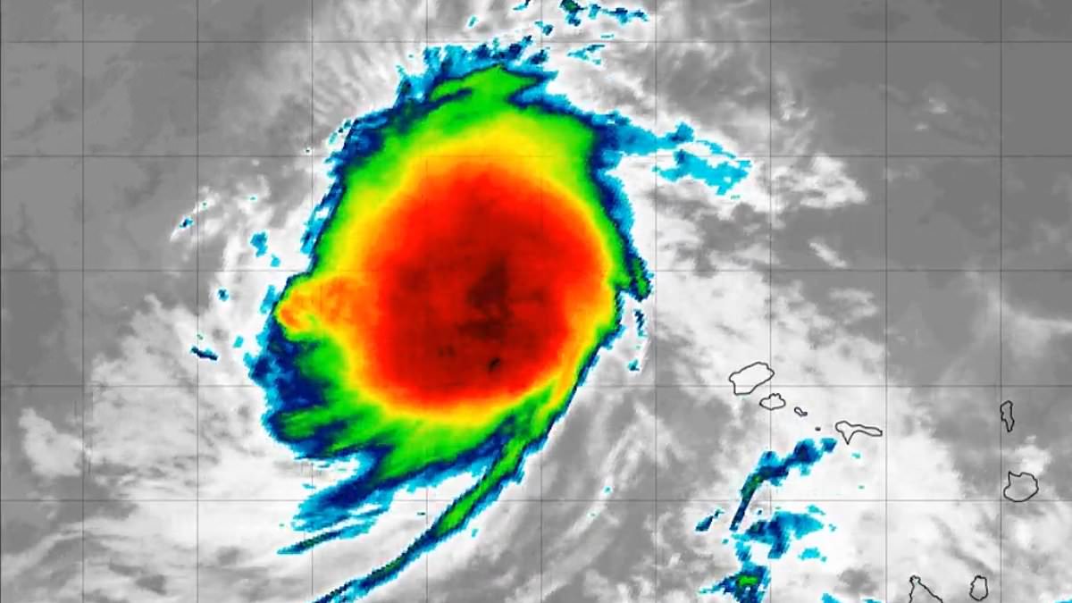
Currently identified as Invest 97L, the storm has a 90 percent probability of evolving into a cyclone within the next week, as reported by the National Hurricane Center (NHC).
Spaghetti models showed it curving northward along the US East Coast, with the potential for landfall or a close approach.
A spaghetti model forecasts possible paths a tropical storm or hurricane might take, based on predictions from multiple weather computer programs.
‘The upper-air pattern late this week favors it turning north and likely staying east of the US East Coast,’ Merrill added.
‘However, rough surf and rip currents could increase along East Coast beaches next weekend into early the following week.’

The current spaghetti models for Invest 97L indicate it could curve northward along the US East Coast, posing a risk of either making landfall or coming very close.

The rainstorm formed off the western coast of Africa and is barreling toward the US through the Atlantic
Locally heavy rain and gusty winds are expected across the Cabo Verde Islands into early this week as the storm moves westward over the Atlantic.
The system rates less than one on the AccuWeather RealImpact Scale for the islands.
By late week, it is forecast to turn northward just north of the Caribbean.
‘Invest 97L is a strong candidate to become the season’s next named storm, Erin,’ WeatherTiger meteorologist Ryan Truchelut mentioned to USA Today.
The NHC noted the system will continue moving west to west-northwest at 15 to 20 mph across the eastern and central tropical Atlantic.
Meteorologist Jim Cantore wrote on X that there is strong confidence the system will intensify as it crosses the Atlantic.
‘It’s already the best-looking wave of the season,’ he said. ‘Most reliable hurricane guidance makes it a hurricane by midweek.
‘The main question is its development: will it stall, and will a mid-latitude trough affect its progress? There’s much to monitor, but the likelihood of our first Atlantic hurricane of 2025, and possibly more, is very high.’

Meteorologists show a 90 percent chance of it developing into a cyclone this week, and believe it will reach hurricane status by Thursday. There are two other disturbances in the Atlanitc
Whether the storm stays well offshore, potentially threatening Bermuda, or shifts toward the US coastline remains uncertain.
The NHC is also monitoring AL96 in the Atlantic, a weak trough of low pressure producing only limited showers and thunderstorms.
Significant development is unlikely as the system drifts northward, with just a 10 percent chance of formation over both the next 48 hours and the next seven days.
In addition, a non-tropical low-pressure system a few hundred miles south-southeast of Nova Scotia, Canada, is drifting over the warm waters of the Gulf Stream, where some tropical or subtropical development could occur within the next day or two.
By midweek, however, it will move into cooler waters, ending its chances of development.
The NHC also places its formation chance at 10 percent over the next 48 hours and seven days.