
Share this @internewscast.com
Tropical Storm Erin has rapidly developed into the first hurricane of the 2025 season, posing a serious risk of heavy flooding along the East Coast, should the current spaghetti models prove inaccurate.
Having been intensifying over the Atlantic throughout the past week, Erin is expected to escalate to a Category 4 hurricane by Monday at the latest as it nears Bermuda.
Meteorologists warned that the hurricane would bring dangerous surf and coastal flooding to millions in the US, from the Carolinas to New England.
However, the situation could deteriorate if Erin challenges the current spaghetti models, which currently predict the storm will divert away from the East Coast as it shifts north in the upcoming week.
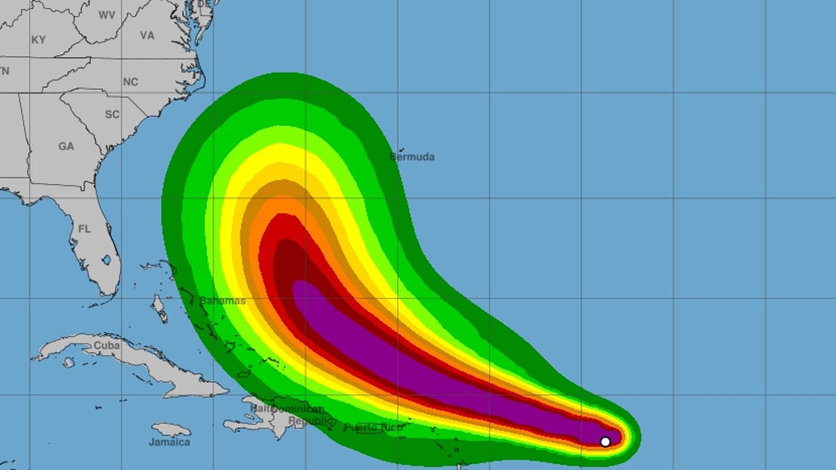
A spaghetti model illustrates the various potential paths a tropical storm or hurricane might take, utilizing forecasts from different weather computer simulations.
Each line represents one model’s prediction of the storm’s trajectory. When the lines cluster closely, it indicates that most models concur on the path, offering a more reliable forecast.
In Erin’s scenario, the majority of spaghetti models indicate the intensifying hurricane will swerve away from the US, though a couple of potential tracks suggest the hurricane could edge much closer to the Carolinas and Virginia.
AccuWeather lead hurricane expert Alex DaSilva warned: ‘Erin has not yet started to curve north. The longer Erin tracks west before turning north, the odds increase of impacts potentially reaching the East Coast.’

Erin officially reached hurricane status Friday morning on August 15, hours ahead of earlier projections

Current projections show that Hurricane Erin will become a Category 3 storm by Saturday as it passes the Caribbean
Erin officially became a hurricane Friday morning, hours ahead of expert predictions, as its winds exceeded 75 mph for the first time since the storm developed.
However, AccuWeather forecasters said it’ll quickly ramp up into a Category 3 storm by Saturday, bringing sustained winds of more than 110 mph as it passes Puerto Rico and the Dominican Republic this weekend.
The AccuWeather team projected that Erin should reach its peak Monday afternoon, as its winds surpass 130 mph, entering Category 4 status for at least a day as it begins to turn towards Bermuda.
If the hurricane doesn’t turn at this point, it could put Erin on course to make landfall in the US, which hasn’t happened since Hurricane Beryl struck Texas in July 2024.
‘Be vigilant if you’re going to an East Coast beach next week. Be aware of rip current warning signs and only swim in areas with lifeguards on duty,’ DaSilva added in a statement.
The East Coast should start feeling the effects of the storm by the beginning of next week.
Meteorologists said the first states Erin will impact will likely be North Carolina and Virginia, where beachfront properties could be at risk.
Rough surf, rip currents, coastal flooding, and beach erosion are all expected to be issues for residents and vacationers in the area as soon as Monday or Tuesday.

Spaghetti models show that Erin is likely to turn away from the US East Coast, but there is still a possibility of a direct hit

Coastal flooding is expected to be a major risk for all states from the Carolinas to New England next week (Stock Image)
As the storm moves over cooler ocean waters and encounters stronger wind shears, Erin is expected to drop to Category 2 strength as it travels along the New England coast next Thursday and Friday, with winds between 96 and 110 mph.
Cooler water provides less energy for hurricanes, and wind shear can disrupt their structure, reducing their overall strength.
However, states like Maine, New Hampshire, and Massachusetts are still projected to see heavy rain and wind later next week.
‘North Carolina’s Outer Banks, Long Island, New York, and Cape Cod, Massachusetts face a higher risk of direct and potentially severe tropical storm or hurricane conditions than much of the southern Atlantic, mid-Atlantic and northern New England coasts,’ the AccuWeather team revealed.

Erin is projected to reach Category 4 by August 18, with sustained winds over 130 mph as it approaches Bermuda
Offshore, the hurricane could cause massive waves in the Atlantic that range between 50 and 100 feet high.
That kind of ocean activity could put cruise ships and cargo freighters in serious danger. For smaller ships, a 100-foot wave could be life-threatening.
The National Oceanic and Atmospheric Administration (NOAA) has predicted an ‘above average’ season that will likely result in more named storms than there were in 2024, when 18 such storms were tracked.
In May, NOAA predicted up to 19 named storms, 10 hurricanes, and five major hurricanes affecting the US this year. The National Hurricane Center noted that approximately 400 people died during 2024’s hurricane season, the deadliest season since 2005.