
Share this @internewscast.com
Hurricane Kiko’s course has shifted and the major storm is now headed straight for Hawaii in a rare weather event for the islands.
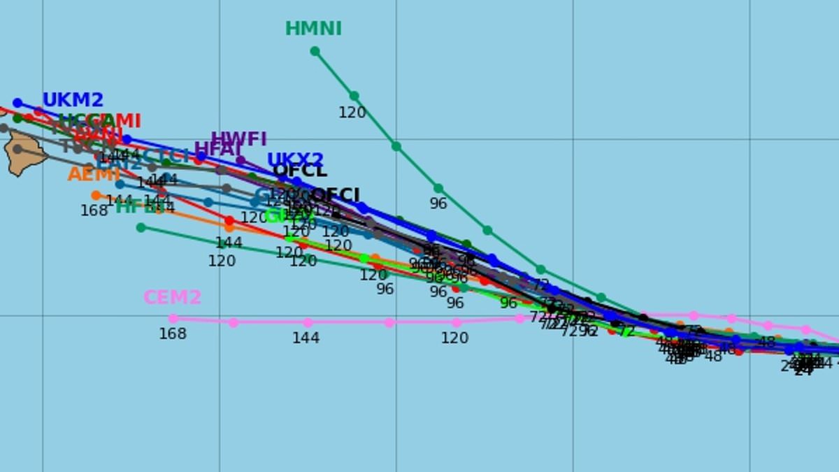
New spaghetti models of the Category 2 hurricane project that the storm will strike Hawaii’s Big Island by next week.
Kiko is currently gaining strength in the eastern Pacific Ocean, with local meteorologists forecasting it will develop into a major Category 3 hurricane by Wednesday.
The storm has sustained winds of more than 100 mph after reaching hurricane status early Tuesday morning.
The last major hurricane to directly strike Hawaii was Hurricane Iniki in September 1992.
It struck as a Category 4 hurricane with sustained winds of 145 mph on September 11, causing an estimated $3 billion in damage.
As anticipated by Hawaiian forecasters, Kiko’s trajectory seems to have shifted slightly to the right, steering it towards the US islands and away from the unstable air that could have compromised the hurricane’s integrity.
The National Hurricane Center (NHC) has projected that Kiko will be within 500 miles of Hawaii by late Sunday night.

New prediction models for Hurricane Kiko warn that the storm may make a direct hit on Hawaii’s Big Island in the coming days

The last major hurricane above Category 3 to directly strike Hawaii was Hurricane Iniki in 1992 (Stock Image)
Officials in Hawaii have not issued any hurricane warnings or alerts as of Wednesday morning.
The weather team from Hawaii News Now mentioned that it’s still premature to precisely determine if the hurricane will strike the Big Island (Hawaii Island), but an increasing number of models are suggesting a direct hit.
A spaghetti model demonstrates the various potential routes a tropical storm or hurricane could follow, based on forecasts from multiple weather computer programs.
Each line in the model indicates one program’s projection of the storm’s path. When the lines converge closely, it signifies a general consensus among models, enhancing the reliability of the forecast.
Forecasters at NHC have projected that Kiko will continue to strengthen, churning into a major hurricane, until Saturday.
At that point, meteorologists expect the hurricane to weaken as it moves into cooler waters closer to Hawaii and encounters more wind shear.
That means Kiko is expected to run into stronger winds blowing at different heights in the atmosphere which can tear apart a hurricane’s structure.
Kiko is already the 11th named system in the eastern Pacific this year, and the Pacific hurricane season still has three months left to go.

The National Hurricane Center has revealed that Hurricane Kiko’s path has shifted, putting it on a course for the Hawaiian Islands next week

Hurricane Kiko entered Wednesday as a Category 2 storm with sustained winds of more than 100 mph
The season runs from May 15 until November 30, making it two weeks longer than the Atlantic hurricane season.
Earlier, the National Oceanic and Atmospheric Administration (NOAA) anticipated a ‘below-normal season’ for the eastern Pacific, projecting 12 to 18 named storms, five to 10 hurricanes, and up to five major hurricanes.
On the other side of the US, NOAA projected an ‘above average’ season in the Atlantic which would likely more named storms than there were in 2024.
Overall, NOAA predicted up to 19 named storms, 10 hurricanes, and five major hurricanes affecting the US in 2025 .
NHC forecasters have been tracking the latest disturbance headed toward the East Coast, which now has a 70 percent chance of becoming a tropical depression by the end of the week, setting up the potential for the next named storm, Gabrielle.