
Share this @internewscast.com
Britain is set to be impacted by Storm Amy, which is predicted to bring 80mph winds and heavy rain to certain areas on Friday and Saturday, according to the Met Office today.
The first named storm of the autumn season will originate from a distinct weather system developing east of Hurricanes Humberto and Imelda, which are also crossing the Atlantic.
The regions in northern and western UK are anticipated to face the brunt of Storm Amy, as its formation is being affected by the remnants of Humberto and Imelda.
Meteorologists have noted that the hurricanes have sped up the Atlantic jet stream, aiding in Storm Amy’s oceanic formation and intensification.
The Met Office has issued a 31-hour yellow rain warning for western Scotland starting from 5pm today until the end of tomorrow, after which Storm Amy is expected to officially arrive.
A subsequent 30-hour yellow wind warning applies to all of Scotland, as well as North West England and North Wales, running from 6pm on Friday until late Saturday. Additionally, a separate 14-hour wind warning for Northern Ireland will be active from 4pm Friday until 6am Saturday.
During the rain alert, forecasters said areas could be ‘cut off by flooded roads or landslides’, while flooding could cause ‘difficult driving conditions’ and road closures.
Power cuts and loss of other services to some homes and businesses are also possible, while flooding could damage buildings and cause train cancellations.

The Met Office has issued this graphic of the three most likely scenarios from Friday

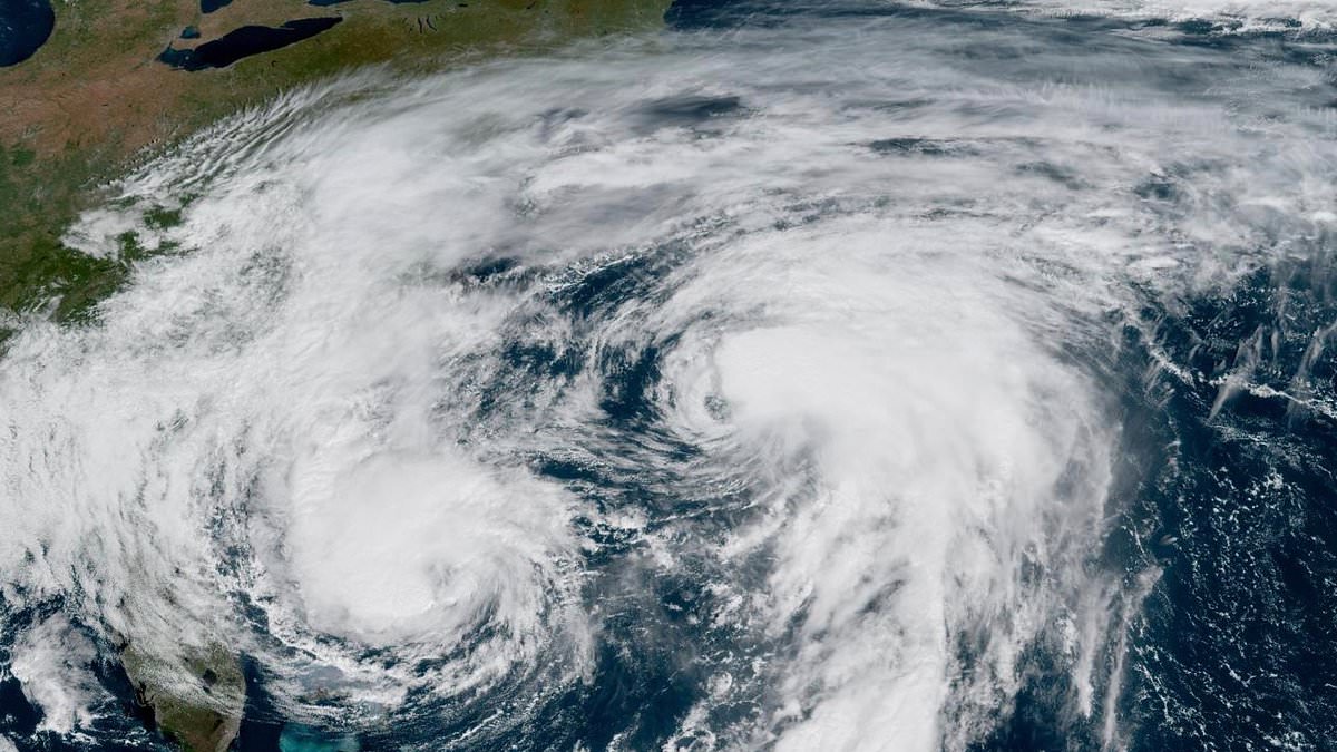
A satellite image shows Hurricane Imelda (left) and Humberto (right) in the Atlantic yesterday
When the wind warning begins, the Met Office said tiles could be blown from roofs and damage homes; while delays to road, rail, air and ferry services will be likely.
Power cuts and mobile phone coverage outages are also possible along with ‘injuries and danger to life from flying debris’ while ‘some roads and bridges could close’.
There is also a chance that ‘injuries and danger to life could occur from large waves and beach material being thrown onto sea fronts, coastal roads and properties’.
Met Office deputy chief meteorologist Tom Crabtree said there was ‘still some uncertainty about the exact track Storm Amy will take’.
But he added: ‘The system will bring gale force winds across northern and western regions, with gusts widely reaching 50 to 60mpg inland in northern Britain, and potentially reaching 70 to 80mph in places, with even stronger gusts on exposed coasts and hills, mainly in the North West.
‘Heavy rainfall is also expected, in particularly over western Scotland, where totals could exceed 30 to 50mm in six to nine hours, increasing the risk of localised flooding.
‘Forecasts and warnings will be updated as the situation becomes more clear, therefore it is important to keep an eye forecast for your area over the coming days.’
Marco Petagna, senior operational meteorologist at the Met Office, tweeted that there would be a ‘conveyor belt of rain associated with waving weather fronts’.
He added that Storm Amy is expected undergo rapid cyclogenesis on Friday.
Also known as a ‘weather bomb’, this is when the central pressure of a low pressure system falls 24 millibars in 24 hours.
The Met Office expects possible disruption to transport, power supplies and outdoor activities, especially from Friday evening into Saturday.
Martin Thomson from Transport Scotland said: ‘Storm Amy is set to bring heavy rain and strong winds to parts of Scotland and we expect to see disruption to the transport network in the warning areas.


The Met Office has a rain warning in place for western Scotland for today and tomorrow (left) and a wind warning for a wider area for Friday and Saturday (right), when Storm Amy will hit

Forecasters warned residents in Scotland to expect ‘pretty incredible rainfall totals’ this week

The US National Hurricane Center map shows the expected track of Tropical Storm Imelda

Waves from Hurricanes Humberto and Imelda hit a home in Buxton, North Carolina, yesterday
‘The rain and wind will bring difficult driving conditions, such as reduced visibility and surface water, and are also likely to affect the ferry and rail networks, so it’s important to plan your journey ahead of time.
‘Motorists should use the Traffic Scotland website before they set off to make sure that their route is available, and you should check with your operator if you are planning to travel on trains, ferries and flights.’
Amy is first in the list of this year’s storm names put together by the Met Office with Ireland’s Met Eireann and the Dutch national weather forecasting service KNMI.
The Met Office and its partners have been naming storms since 2015, with the list running from early September to the following August.
This is to coincide with the start of autumn, when the likelihood of low-pressure systems and the potential for storms severe enough to be named increases.
In the last year, six storms were named, reaching the letter F with Storm Floris on August 1.
Under naming conventions used for storms in the North Atlantic, the list runs alphabetically, missing out Q, U, X, Y and Z, and names are drawn from submissions from the public in the UK, Ireland and the Netherlands.
The first name in this year’s list, Amy, was the most popular female name submitted to the Met Office.
Storms are given a name when they are deemed to have the potential to cause medium or high impacts in the UK, Ireland or the Netherlands, with wind the primary focus, although additional issues from rain or snow are also looked at.