
Share this @internewscast.com
Tropical Storm Melissa has emerged as the 11th named storm of the 2025 Atlantic hurricane season, according to the latest updates.
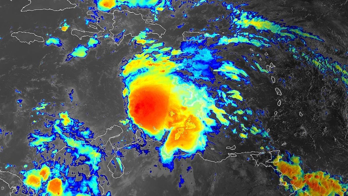
The National Hurricane Center (NHC) made the announcement on Tuesday at 11 a.m. ET, confirming that the weather system previously known as Invest 98L has evolved into a tropical storm. This transformation was marked by the development of a distinct center and organized thunderstorms.
“Satellite imagery indicates the system is asymmetric, with the low-level center positioned near the western edge of the central dense overcast,” the NHC stated.
The NHC reported that the storm’s initial strength is estimated at 50 mph, based on recent satellite data, officially recognizing it as Tropical Storm Melissa.
This afternoon, an Air Force Hurricane Hunter aircraft is scheduled to investigate the storm, providing more precise information on its intensity and structure.
Forecasts suggest that in the coming days, Melissa will decelerate and shift northward, moving toward a weak point in the prevailing weather pattern. This trajectory could bring the storm close to the southwestern edges of Haiti and Jamaica by Thursday.
After that, the NHC alert warned that computer models disagree. Some show Melissa turning northeast, while others predict it could stall or drift west. Most models suggest the storm will stay in the Caribbean through the weekend.
However, some spaghetti models have suggested a dangerously close approach to Florida, with meteorologists warning the US is not out of the clear just yet.

Tropical Storm Melissa formed in the Caribbean Sea on Tuesday morning

Storm Melissa is producing 50mph. Hurricane trackers said it should reach Haiti and Jamaica by Thursday
The NHC said that Melissa is moving over very warm water, which could help it strengthen.
However, wind shear and dry air might limit its growth. Because of this, forecasters expect it to strengthen slowly rather than rapidly.
Its future strength will depend on its track, which is still uncertain, the agency explained.
AccuWeather lead hurricane expert Alex DaSilva said in a statement: ‘While we think that the chances of a direct U.S. hit from this storm are low right now, it’s still on the table should the tropical system make it into the western Caribbean.’
In October, tropical storms entering the western Caribbean typically veer away from Texas and Louisiana.
However, the eastern US, especially Florida, remains at risk for powerful storms.
AccuWeather also said it is possible the system could become the next hurricane of the season in the warm waters of the central Caribbean.
The Meteorological Service for Jamaica issued a Tropical Storm Watch before the storm was named.
‘When the system is in the vicinity of Jamaica, it is expected to produce locally heavy rainfall, strong gusty winds, possibly reaching tropical storm force, primarily over northeastern and southern parishes late Wednesday and Thursday, the alert stated.

While most forecast models keep the continental US out of immediate danger, some models suggest a potential direct path toward Florida or a dangerously close approach
Although models show uncertainty about the system’s path, storm chaser Mitch West warned on X: ‘You would be a fool to say this has zero percent chance of impacting the US.
‘The chances are low, but it’s certainly possible, and we have surely seen it happen in the past. With a large trough signal showing up at the end of the month, you can have weird stuff happen depending on its position.
‘A trough doesn’t always push things out to sea; it can sometimes pull on things.”
‘Folks all through the Antilles from Puerto Rico to Cuba should be prepared for potential impacts from this system if it develops.’
Andy Hazelton, associate Scientist at the University of Miami CIMAS, shared the three scenarios on X over the weekend.
Scenario one shows the storm making a quick northeastern turn across Hispaniola, with a path mostly affecting the Dominican Republic and Haiti.
The second suggests the system stays weak and develops deeper in the Caribbean, moving closer to Nicaragua or Honduras.
The third scenario shows the storm taking longer to form, but developing into a powerful hurricane in the northwest Caribbean.
This track could threaten Cuba, the Bahamas, and potentially extreme South Florida and the Keys.
‘I’m personally leaning more towards Scenarios 2 or 3, with slower development and a track either towards Central America or into the NW Caribbean, but certainly Scenario 1 is on the table if it gets organized and feels the weakness to the north,’ said Hazelton.
‘Folks all through the Antilles from Puerto Rico to Cuba should be prepared for potential impacts from this system if it develops.’