
Share this @internewscast.com
Fifth time’s the charm? Following a lot of speculation and numerous false alarms about ghost storms spreading online, the Atlantic has now seen its first hurricane of the year: Erin.
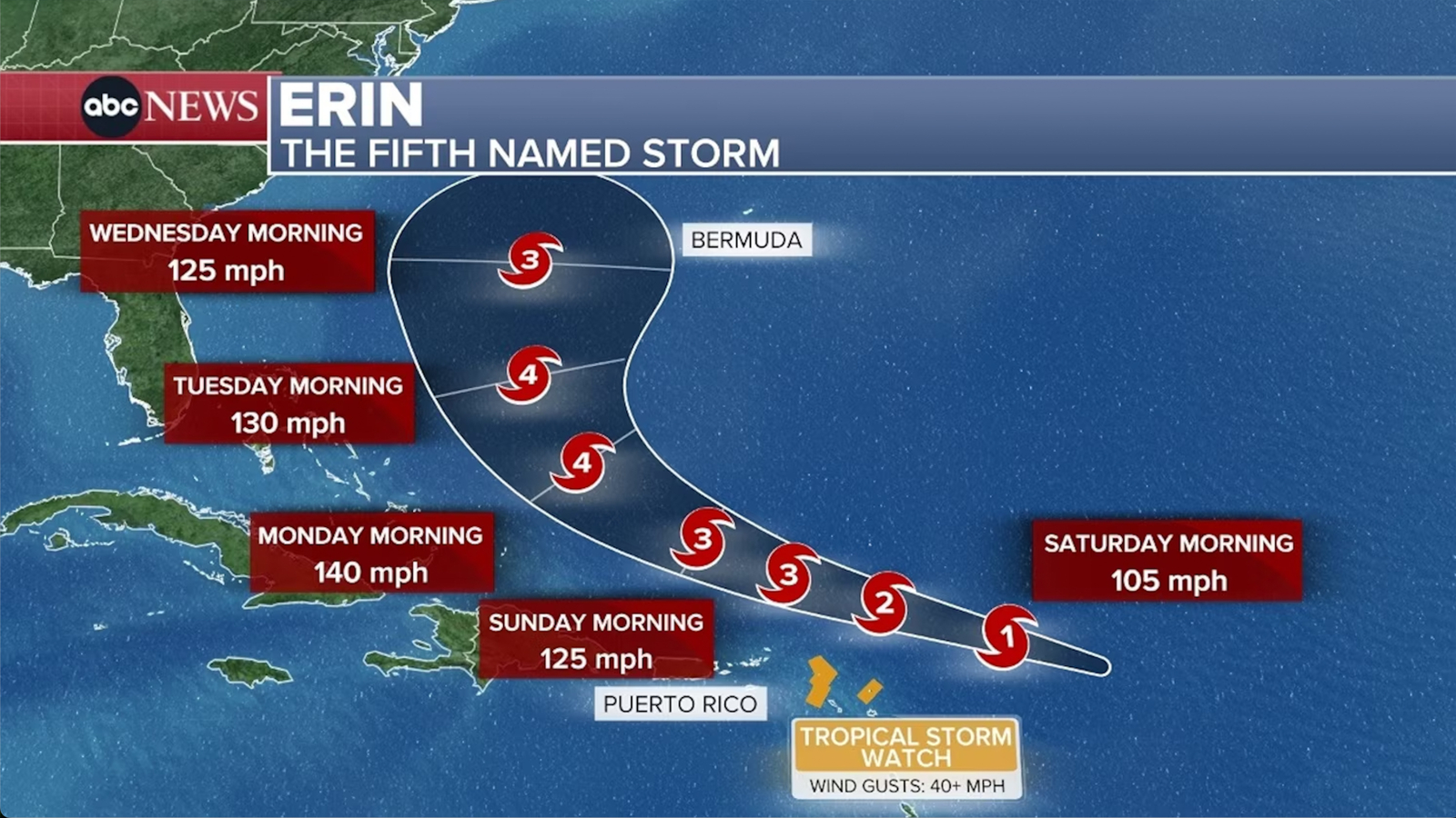
Erin evolved into a Category 1 hurricane with winds sustained at 85 mph by Friday evening, positioned over 300 miles east of the northeastern Caribbean’s Leeward Islands, based on information from the National Hurricane Center.
The hurricane might bring gusty winds, rainfall, choppy seas, and rip currents to regions of the far northeastern Caribbean as it moves just north of the islands during the weekend.
Erin was tracking west-northwest on Friday evening and is expected to strengthen over the next few days as it cruises across the Atlantic.
It is forecast to become a Category 3 hurricane as soon as Saturday night and could be a Category 4 hurricane Sunday night.
Four other systems roamed the Atlantic basin before Erin – Andrea, Barry, Chantal and Dexter – but none were stronger than a tropical storm.
This year’s first hurricane is arriving slightly later than usual. Normally, the initial hurricane of the season develops around August 11, although early appearances have been noted in recent years. By this point last year, there had already been three hurricanes: Beryl, Debby, and Ernesto.
Forecasts suggest Erin will pass just north of the Leeward Islands, the Virgin Islands, and Puerto Rico over the weekend, while gradually turning northward.
Tropical storm watches have been issued for sections of the northern Leeward Islands, with the potential to upgrade these to tropical storm warnings. Such a warning would signal that winds of tropical storm strength are predicted to start in the region within the next 24 hours.
Direct landfall on any of the Caribbean islands is unlikely, but not impossible, if Erin’s path wobbles in the coming days.
It’s more likely that Erin will churn up rough seas and produce rip currents in the Caribbean through the weekend and into early next week. Gusty wind and rain – which could be heavy at times – are also possible depending on exactly how close Erin tracks to the islands. The storm’s intense rain could also cause flash flooding or mudslides.
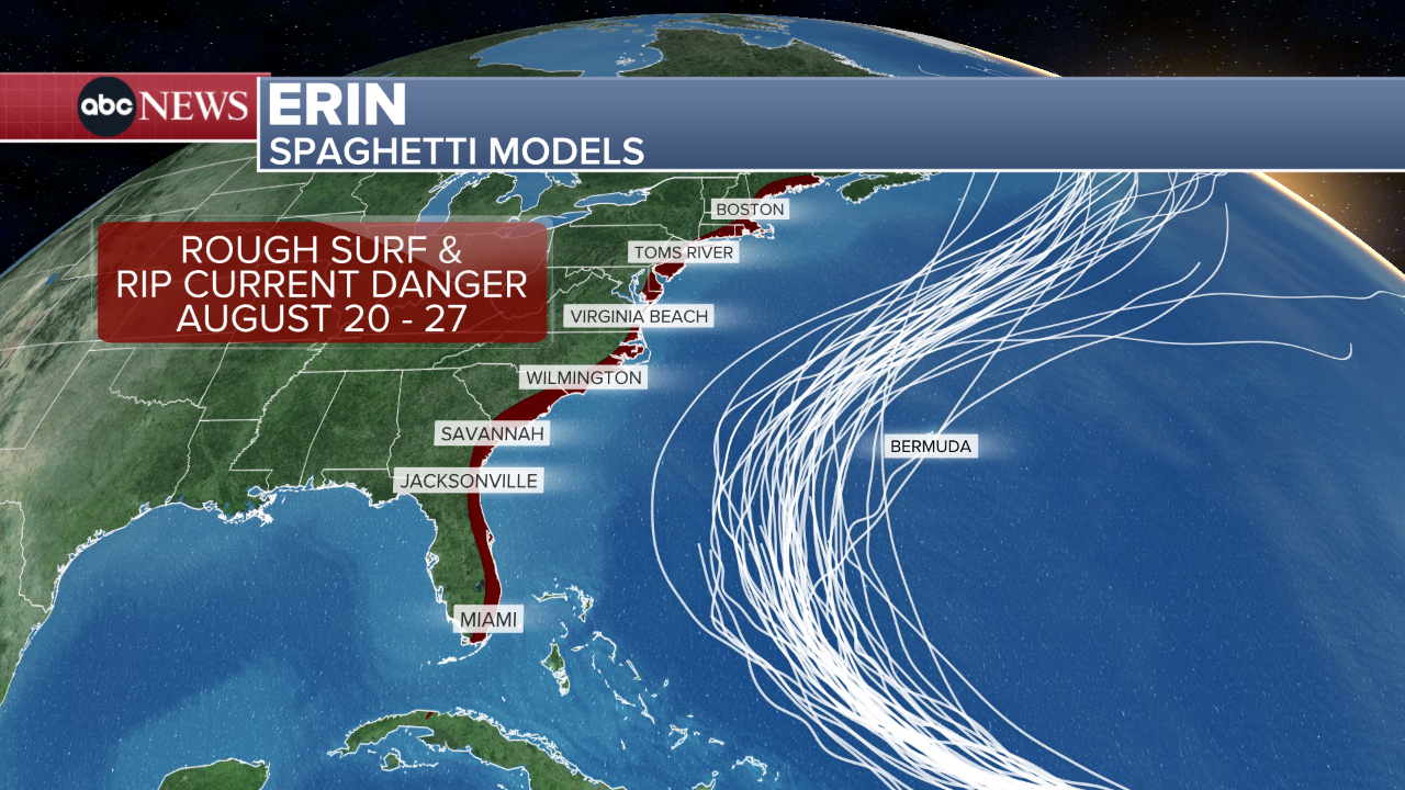
It’s too soon to know what kind of threat Erin could pose to Bermuda. Any potential impacts to the island should become clearer early next week. The hurricane is currently forecast to stay away from the United States, but that’s not an absolute certainty. Even if it does remain offshore, Erin could also generate rough surf and dangerous rip currents along the US East Coast next week.
Erin’s track could depend on this factor
How quickly Erin strengthens in the coming days could be the key factor in its eventual path.
There’s plenty of fuel for Erin to tap into in the western Atlantic as sea surface temperatures are much warmer than normal. They aren’t quite as warm as the record levels reached in 2023 and 2024, but are still far warmer than they’d be in a world that wasn’t heating up due to fossil fuel pollution.
Erin is expected to explode in strength over the very warm water of the western Atlantic and rapidly intensify into the season’s first major hurricane – Category 3 or higher – Saturday.
Rapid intensification occurs when the winds roaring around a storm’s center increase by at least 35 mph in 24 hours or less. Last year, nine storms rapidly intensified in the Atlantic basin, including Hurricane Helene and Hurricane Milton.
When hurricanes grow stronger, their storm clouds also grow taller and reach higher into the atmosphere. That extra height allows them to tap into the faster winds present higher in the atmosphere that can pull the storm more to the north.
The Bermuda High – a large, semi-permanent area of clockwise circulating high pressure that meanders over the Atlantic Ocean – is often in the driver’s seat in this case: When the high turns the steering wheel, the hurricane generally follows.
But if Erin develops more slowly, the system could stay lower in the atmosphere, where the trade winds – winds that flow clockwise around the equator – could keep it tracking to the west and prevent it from turning.
Which scenario wins out will become clear by the weekend, but any islands in the potential path of Erin should prepare ahead of time.
Other potential tropical trouble
August is when the tropics usually come alive: The busiest stretch of the season typically spans from mid-August to mid-October. Forecasters expect above-average tropical activity this year and more storms could form in short order.
The most immediate chance of additional tropical development after Erin was an area of stormy weather forecasters were watching in the Gulf early Friday. But that storminess was not able to form into a tropical depression before it moved onto land in the early afternoon.
Despite missing its chance to develop, the disorganized area of steady rain and a few thunderstorms will dampen parts of far southern Texas in the early afternoon before easing up in the evening. The rain could cause some flooding, especially along low-lying or poor drainage areas, according to the National Weather Service in Brownsville, Texas.
There will be more chances for tropical systems to develop this month. Longer term forecasts from the Climate Prediction Center highlight the same part of the Atlantic Erin developed in as a place to watch for new storms into at least early September.
Featured video is from a previous report.