
Share this @internewscast.com
Forecasters urged people in the Bahamas and along the southeastern coast of the United States to pay close attention to the storm.
MIAMI — Crews were busy on Saturday getting ready for a weather system yet to be named, which is predicted to approach the South Carolina coast as a hurricane by early next week.
South Carolina Gov. Henry McMaster encouraged residents on Saturday afternoon to keep a close eye on the weather and stay vigilant with the potential for severe conditions looming over the state.
Similarly, North Carolina Gov. Josh Stein declared a state of emergency on Saturday in anticipation of the system that the National Hurricane Center in Miami is identifying as Tropical Depression Nine. Notably, a year ago, Hurricane Helene wreaked havoc on areas of South Carolina and North Carolina.
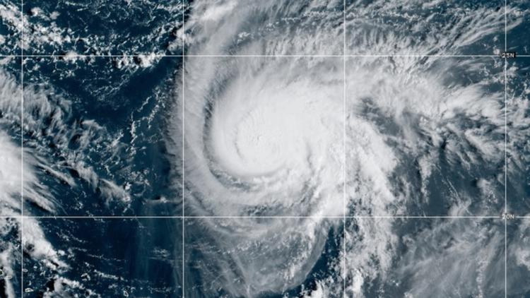
By Saturday afternoon, the system was situated approximately 120 miles (190 kilometers) south-southwest of the Central Bahamas. Forecasters advised residents in the Bahamas and along the southeastern coast of the United States to closely monitor the storm’s developments.
“Every time we learn that we can never predict where they will go,” McMaster stated during a news conference on Saturday afternoon about the storm. “This particular storm is gravely serious. Not just serious. Gravely serious.”
He noted that the storm might bring strong winds and heavy rains, potentially causing flooding. In response, the state was positioning search and rescue crews ahead of the weekend.
Meantime, Hurricane Humberto remained a powerful Category 4 hurricane on Saturday afternoon, with maximum sustained winds of 145 mph (230 kph), according to the National Hurricane Center’s latest advisory. The storm was located about 365 miles (587 kilometers) northeast of the northern Leeward Islands. It was moving west at 8 mph (13 kph).
Humberto could produce life-threatening surf and rip currents for the northern Leeward Islands, the Virgin Islands, Puerto Rico and Bermuda over the weekend, forecasters said.
The National Weather Service in Puerto Rico issued a small craft advisory, urging people to stay ashore and avoid unnecessary trips, with Saturday’s swells from Humberto expected to reach about 7 feet (2 meters) in Atlantic waters. They also advised residents to heed the beach warning flag system because of the high risk of rip currents.
Coastal and urban areas of the island were also under an extreme heat warning.
The unnamed system was threatening parts of the Bahamas and Cuba with heavy rainfall and flash flooding on Saturday, with portions of the Bahamas were under a tropical storm warning. More warnings and watches were expected on Saturday night and Sunday, the hurricane center said.
The Bahamas’ Department of Meteorology urged residents in the northwest and central islands, which include New Providence, Andros Island, San Salvador and Long Island, to “make final preparations” for possible tropical storm conditions to begin late Saturday or early Sunday. They noted rainfall in the central and southeast Bahamas could reach between 4 and 8 inches (10 and 20 centimeters), with some isolated areas seeing up to 10 inches (25 centimeters).
“Residents in low-lying areas should take actions to mitigate property damages due to flooding,” the department warned in a statement.
Florida officials keep an eye on storm
Gradual strengthening into a tropical storm is expected by Sunday as the system runs parallel offshore of Florida’s Atlantic coastline.
Officials across South Florida, which has been saturated by rain throughout September, continued keeping an eye on the system. A tropical storm watch was issued Saturday for parts of the Florida coastline north of West Palm Beach to an area north of Daytona Beach.
In Homestead, Florida, which was devastated by Hurricane Andrew in 1992, Emergency Manager Jaime Hernandez worried about complacency among residents.
“Too many South Floridians who may have experienced limited impacts from storms that came close in recent years, such as Hurricane Irma in 2017, have come away from these events mistakenly believing they have ‘been through the big one,’ ” Hernandez said.
He notes that Homestead is one of only four communities in the continental U.S. to experience the catastrophic impacts of a Category 5 hurricane. “We know all too well the importance of having an emergency plan and remaining informed,” Hernandez said.
The tropical disturbance brought heavy rains in the Dominican Republic on Friday, leading authorities to evacuate hundreds of people and declare a red alert in five provinces.
Flooding in the southwestern province of Azua displaced at least 774 people, and 26 were being sheltered due to the overflowing of the Tábara River, Civil Defense spokesman Jensen Sánchez told The Associated Press.
In the eastern Atlantic, the center of post-tropical cyclone Gabrielle moved away from the Azores. A hurricane warning for the entire Portuguese archipelago was discontinued.
Gabrielle was expected to approach Portugal’s coast by early Sunday. Swells expected to produce life-threatening surf and rip currents were expected to reach Portugal, northwestern Spain and northern Morocco on Saturday.
Hurricane in the Pacific Ocean
In the Pacific Ocean, Hurricane Narda was churning about 1,025 miles (1,650 kilometers) west-southwest of the southern tip of Baja California and heading west-northwest at 12 mph (19 kph). The Category 1 storm was expected to maintain its strength on Friday before weakening over the weekend.
Swells generated by Narda were affecting coastal Mexico and Baja California Sur, forecasters said. The swells that could bring life-threatening surf and rip current conditions were expected to reach Southern California over the weekend.
Associated Press writer Regina Garcia Cano reported from Caracas, Venezuela.
Copyright 2025 Associated Press. All rights reserved. This material may not be published, broadcast, rewritten, or redistributed.