Share this @internewscast.com
The National Hurricane Center (NHC) has announced that Humberto has now reached hurricane status, and there is also an increase in the development likelihood of another weather disturbance in the Atlantic.
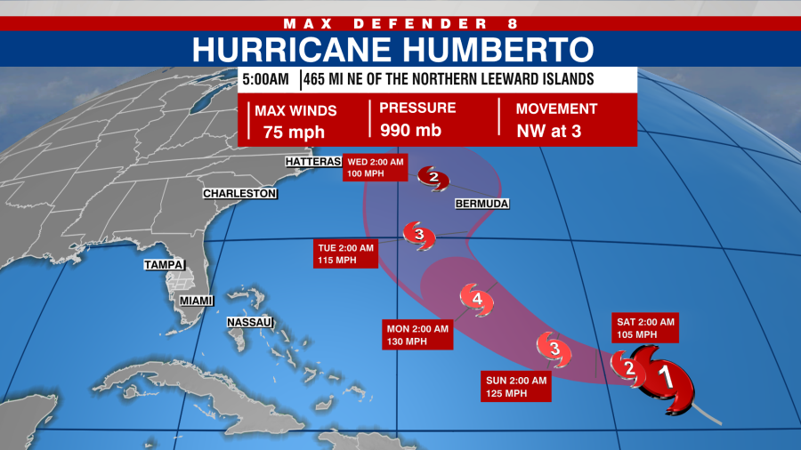
Located about 465 miles northeast of the Northern Leeward Islands, Humberto is moving toward the northwest at about 3 mph.

According to the NHC, significant strengthening is forecasted, and Humberto is expected to become a major hurricane this weekend.
A slow west-northwest to northwest motion is expected over the next few days.

The maximum sustained winds have increased to about 75 mph.
There are no coastal watches or warnings in effect.
Southwestern Atlantic
Showers and storms associated with a tropical wave continue to show signs of organization near Hispaniola and the Turks and Caicos Islands.
According to the NHC, an area of low pressure is expected to form along the wave today when it is near the southeast Bahamas.

The low is expected to become a tropical depression today or over the weekend when it is in the area of the central and northwest Bahamas.
The disturbance will then track northwestward or northward over the southwestern Atlantic.
The NHC stated, “Although there is considerable uncertainty regarding the long-range path and strength of the system, there is a growing probability of it affecting the southeast U.S. coast with wind, rainfall, and storm surge over the coming days.”

The chance of formation in the next 48 hours is 80 percent.
The chance of formation in the next seven days is 90 percent.
Post-Tropical Cyclone Gabrielle
The center of post-tropical cyclone Gabrielle continues to move through the Azores, the NHC said.
Gabrielle will start moving away from the Azores during the next few hours, then approach the coast of Portugal by early Sunday.
Maximum sustained winds are near 65 mph.
According to the NHC, little change in strengthening is likely through Friday night, but gradual weakening should begin on Saturday.