
Share this @internewscast.com
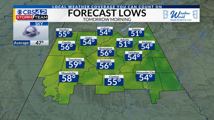
Tonight: Increasing clouds as southerly winds bring in moisture. It will not be as chilly with lows in the lower to middle 50s.

Tomorrow: High pressure will move east of Alabama on Friday, sending more moisture northward from the Gulf. Expect a mix of sun and clouds with warmer high temperatures around 80º.

Weather Aware late Sunday Night through Monday Morning

Weekend Outlook: Rain and storms return this weekend. An upper-level wave will move across the state on Saturday setting off scattered showers throughout the day. Highs will be in the mid-70s. You will want your umbrella if you are headed to any of the NCAA Women’s Basketball games at Legacy Arena!


A trough of low pressure will send a cold front across Alabama Sunday night into Monday. Most of Sunday will be mostly cloudy, breezy, and warm with a few showers. Highs will be in the lower 80s. Showers and storms will form ahead and along the front on Sunday night across Mississippi and move across Central Alabama early Monday morning. These could be strong to severe with gusty winds, hail, and a few tornadoes.


SPC has already placed Central Alabama at a level 2/5 Slight Risk through midday Monday. This is why you need to be Weather Aware! It is too early to get into specifics with the severe threats. We continue to watch this develop, and we will have a better idea of how intense the storms will be on Friday.


Next Week’s Outlook: Monday begins with the strong to severe storms in the morning, but they will end by the afternoon. It will be cooler with highs in the 70s. High pressure builds in on Tuesday with sunshine and warm highs in the 70s. Another system arrives on Wednesday into Thursday with scattered showers and storms. Some of the storms could be strong to possibly severe. It stays warm with highs in the lower 80s. We dry out by Thursday afternoon through Friday with highs still in the 80s.


