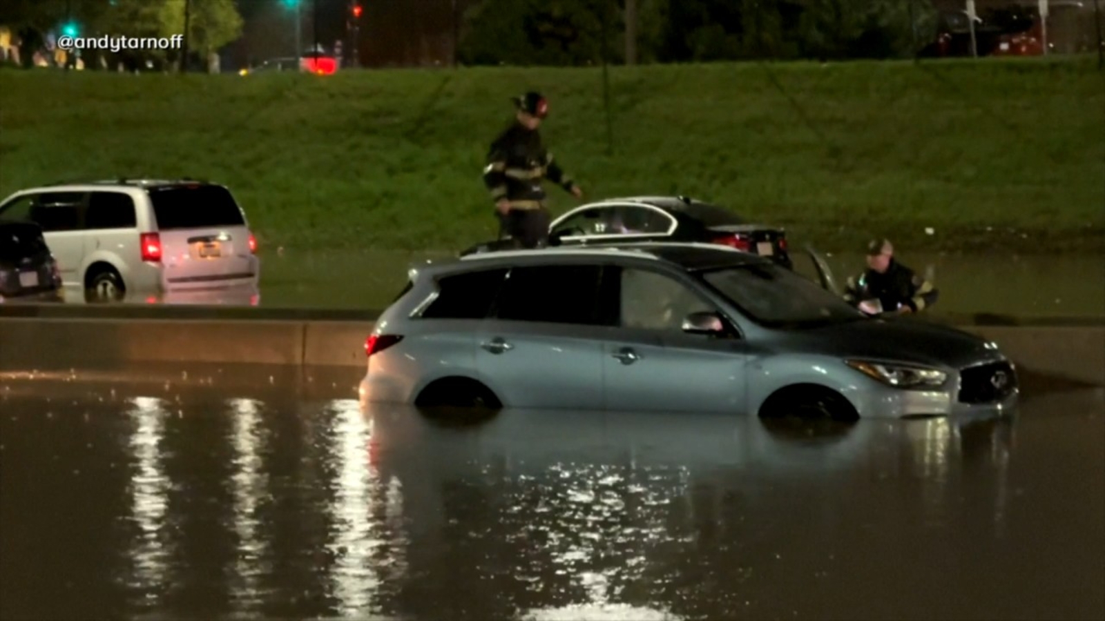

ANN ARBOR, Mich. — Torrential rains in Wisconsin led to severe flooding on Wednesday, submerging roads, stranding vehicles, and prompting authorities to shut down parts of a major highway. Meanwhile, other states in the Midwest were grappling with recovery efforts following recent storms.
In Milwaukee, floodwaters left cars marooned on a highway. A dramatic rescue, captured by the Milwaukee Journal Sentinel, showed emergency responders saving a woman and child from a submerged car.
The Milwaukee County Sheriff’s Office took to social media, urging residents to avoid driving in the southeastern region of Wisconsin.
In response to the severe weather that began sweeping through the area on Monday, Wisconsin Governor Tony Evers declared a state of emergency. The storms unleashed powerful winds, hail, and deluges of rain, with at least three tornadoes confirmed and the threat of further severe weather looming.
Simultaneously, Michigan communities were dealing with the aftermath of fierce overnight storms that wreaked havoc, damaging two ice rinks, flooding roads, and toppling trees.
Reports indicated wind gusts reaching up to 70 mph (113 kph) at the University of Michigan football stadium, with similar conditions recorded at Willow Run Airport, according to meteorologist Sara Schultz. The National Weather Service dispatched teams to assess damage in areas like Ann Arbor to determine the presence of tornado activity.
Another round of strong storms with potentially damaging winds was moving into the area Wednesday from states to the west.
Schools and ice arenas damaged
Some public school buildings in Ann Arbor suffered structural damage and many lost power. The district was closed because of a fiber outage impacting fire, phone and camera systems, and building access.
Ann Arbor Mayor Christopher Taylor said structural engineers were assessing damage to a wall at the city’s Veterans Memorial Park Ice Arena. Part of the roof was torn from the university’s Yost Ice Arena.
The storm uprooted a hulking tree outside Seungjun Lee’s home in Ann Arbor, barely missing his upstairs bedroom.
“If the tree fell down a couple more feet, I would not be standing here,” said Lee, a 20-year-old junior at U-M.
Lee and his roommates were awakened by a siren, then an alert blasted from their phones between 1 a.m. and 2 a.m., urging them to take shelter.
More rain and dead fish
The storms dumped as much as 2.5 inches (6.3 centimeters) of rain across parts of southeastern Michigan by Wednesday morning, and more was expected across the Midwest, Great Lakes and Ohio Valley regions. Flood watches were issued for a big chunk of Michigan’s eastern Lower Peninsula, southeastern Michigan, northern Indiana, northwestern Ohio, the Chicago area and Wisconsin.
In northern Michigan, a power outage during a storm killed 1,750 steelhead trout at a state facility where eggs and milt are collected to produce more fish. Scott Heintzelman of the state’s fisheries division said it was a “devastating event” involving “big, beautiful fish.”
Heintzelman said staff discovered Tuesday that a loss of electricity had stopped the flow of oxygenated water, dooming the fish.
Wisconsin’s Department of Natural Resources said it was watching levees around Portage, a city of about 10,000 people, as the Wisconsin River rises. As of Wednesday morning, the river there swelled to nearly 19 feet (5.7 meters), about 2 feet (0.6 meters) over flood state, and could rise to about 20 feet (6.1 meters), they said.
After days of rainfall and winter snow melt, a “significant influx of water” is also entering Black Lake, in northern Michigan, the sheriff’s office said.
The lake empties into the Black River and feeds the Cheboygan River, which flows through the city into Lake Huron. Officials have been managing that flow through the city’s Cheboygan Dam by raising gates, adding pumps, raising a bridge and closing some riverfront to the public.
Flooding and unsafe travel forced Cheboygan Area Schools to cancel classes and athletic events for Thursday and Friday.
“Conditions are not improving significantly and, in some areas, continue to worsen,” the district said.
Where’s all this weather headed?
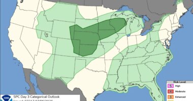
Bill Bunting, a meteorologist with the weather service’s Storm Prediction Center, described a “very dynamic weather pattern” that combines very moist air with a strong jet stream across the central United States and Great Lakes to create conditions for severe thunderstorms.
By Wednesday afternoon, the weather service had received more than 400 reports of hail, winds above 60 mph (96.5 kph) or tornadoes, he said.
The system was stretching northward Wednesday night from central Texas into Iowa and southern Wisconsin and then eastward across parts of Michigan, Illinois, northern Indiana and Ohio on its way toward upper Pennsylvania and the Buffalo, New York, area, Bunting said.
Further east, it is expected to be as hot as a furnace, threatening record high temperatures in New York, Philadelphia and Washington through the weekend, forecasters say.
___
Williams reported from West Bloomfield, Michigan. Associated Press writers Ed White in Detroit, Todd Richmond in Madison, Wisconsin, and Hallie Golden in Seattle, contributed to this story.
Copyright © 2026 by The Associated Press. All Rights Reserved.