
CENTRAL ILLINOIS (WCIA) — Severe weather is impacting Central Illinois, and viewers are sending in updates and media. Stay updated with the latest information as it comes into WCIA’s newsroom.
7:39 p.m.
Ameren has reported how many people are without power in the following areas:
- Decatur: 4,116
- Clinton: 1,479
- Champaign: 753
- Potomac: 453
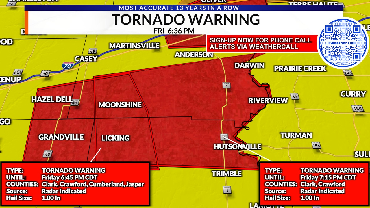
6:36 p.m.
A tornado warning has been issued for part of Crawford and Clark Counties until 7:15 p.m.

6:30 p.m.
A tree fell down in Urbana, completely covering a car and the intersection of Shurts and Anderson Streets.


5:53 p.m.
A tornado warning has been issued for part of the following counties: Effingham, Cumberland, Shelby, Jasper until 6:30 p.m.

5:30 p.m.
Around 1,000 people are without power in the Springfield area, City Water, Light and Power said.
Authorities have reported that the power outages are due to severe weather causing damage to power poles and lines. Initially, about 1,600 customers lost power by 3:30 p.m., but this number has decreased to 1,000 by 5:30 p.m.
The hardest-hit areas include over 400 customers affected in the Harvard Park neighborhood and another 400 in the vicinity from South Pope Street/South 23rd Street to Dirksen Parkway, between East Cook Street and Laurel Street.
5:05 p.m.
Ameren reported the following number of customers without power:
- Christian — 371
- Sangamon — 341
- Macon — 313
- Logan — 256
- Champaign — 113
5 p.m.


4:53 p.m.
The dust storm advisory in East-Central Illinois has been upgraded to a dust storm warning. It will remain in effect until 6:45 p.m.
4:52 p.m.
The National Weather Service of Central Illinois posted the following update on its Facebook page:
“The Blowing Dust Advisory has been expanded to as far west as I-55, and and a High Wind Warning is now in effect for Champaign, Vermilion, Douglas, and Edgar Counties. Wind gusts up to 70 mph have been occurring outside of the storms, due to dry air being drawn downward. These strong winds are causing near zero visibility in open areas where there is loose dirt being lofted.”
4:47 p.m.
A severe thunderstorm warning has been issued for parts of the following counties: Vermilion, Edgar, Clark and Coles until 4:45 p.m.

4:40 p.m.
New video is coming in showing the blowing dust from around Central Illinois.
4:25 p.m.
A crash has been reported on Interstate 74 near St. Joseph amidst a dust storm. People are advised to avoid traveling at this time.
Illinois State Police confirmed the crash was caused by the weather and the driver has been hospitalized.


4:15 p.m.
A wind gust of 69 miles per hour has been recorded at Willard Airport in Savoy.
Meanwhile, the tornado warnings issued for Effingham and Cumberland Counties have expired.
4:07 p.m.
A severe thunderstorm warning has been issued for parts of the following counties: Jasper, Clay, and Effingham until 4:45 p.m.

4:06 p.m.
Tree limbs have snapped in Shelbyville as a result of the severe weather. Meteorologist Kevin Lighty reports from the scene in the SK Exteriors Stormtracker.
4:03 p.m.
The storm shelter at the Effingham Public Library is now open.
In addition, a severe thunderstorm warning has been issued for parts of the following counties: Macon, Piatt, Shelby and Moultrie until 4:45 p.m.


3:48 p.m.
A tornado warning has been issued for part of the following counties: Effingham, Jasper, Cumberland, and Clay until May 16, 2025, at 4:30 p.m.

3:40 p.m.


The National Weather Service of Central Illinois is reporting that severe thunderstorms are crossing I-55 and heading east-northeast toward I-57. The NWS and the Illinois Emergency Management Agency, reported hailstones ranging from ping pong ball- to golf ball-sized.
WCIA received the images above from viewers in Sangamon County, showing some of those ping pong ball-sized stones.
“Storms will continue to quickly move northeast toward I-57 through late afternoon,” the NWS added.
Hailstones that fall later in the day could grow larger than what fell in Springfield, and wind could gust at 60 to 70 miles per hour. Tornadoes are possible and a tornado watch has been issued for Vermilion County.
3:36 p.m.
More than 1,000 people are currently without power on the west side of Sangamon County.
According to Ameren’s outage map, there are currently 1,142 without power just west of Loami.
3:33 p.m.
A severe thunderstorm warning has been issued for parts of the following counties: Christian, Macon, Sangamon, and Shelby until 4:15 p.m.

3:25 p.m.
A severe thunderstorm warning has been issued for parts of the following counties: De Witt, Sangamon, Logan, and Macon until 4:15 p.m.

3 p.m.
A tornado watch has been issued for almost all of the WCIA 3 Viewing area until 10:00 p.m.