
The week kicked off with hot and humid weather. Afternoon temperatures climbed into the upper 80s to lower 90s, but due to the high humidity, the heat index soared into triple digits at times.
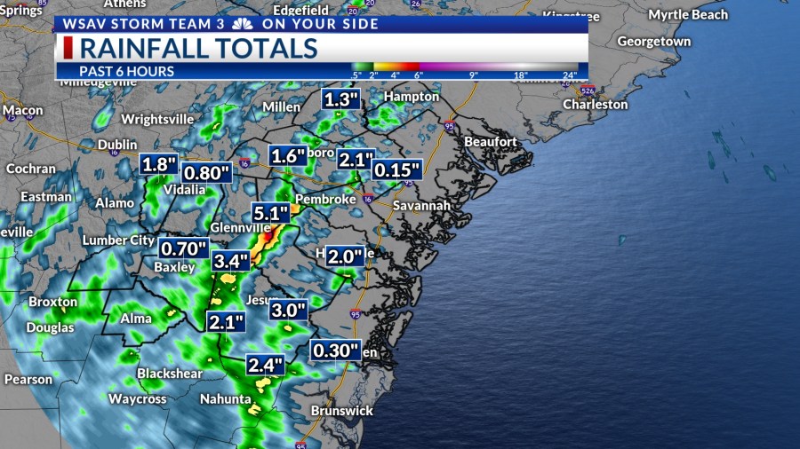
We experienced showers and thunderstorms that lasted into the early evening. According to VIPIR Radar rainfall estimates, many places received more than 2-3″ of rain, with eastern Tattnall County likely getting around 5″.

A LOOK AHEAD
Heavy rain could continue intermittently throughout the week. The greatest chances of rain will be on Tuesday, Wednesday, and Thursday, with storms expected to occur after lunch and continue into the early evening.
Rain chances for Independence Day on Friday look to back off a little. However, they don’t go away all together. If you have outdoor plans or will be attending one of the many fireworks shows, keep an eye to the sky for showers and storms.
Be sure to have a plan ‘B’ and have a place you can go to seek shelter if any storms develop over your area.
Temperatures each day will be in the upper 80s to lower 90s with heat index values approaching 100°F at times.


THE TROPICS
The National Hurricane Center is monitoring an area of cloudiness in the northern Gulf right now. A cold front that is moving southward is expected to stall out in this same area. It is possible for a tropical or subtropical low will develop in this area.
This system is forecast to cross over Florida in the coming days and emerge over the Atlantic Ocean. The overall risk for development from this area is low (20%).
No other development is expected across the Atlantic basin within the next 5 to 7 day.


