Central Florida is bracing for another sweltering day marked by dangerous heat and the threat of strong afternoon thunderstorms, a pattern forecasters say will likely persist through Father’s Day weekend.
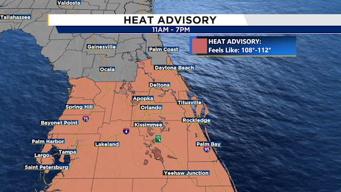
For Thursday, a Heat Advisory remains in effect from 11 a.m. to 7 p.m. across East Central Florida. Heat index values are expected to reach between 108 and 110 degrees, even though actual high temperatures will stay in the mid-90s. The added humidity will make conditions feel significantly hotter.
By the afternoon, storm chances are expected to rise as sea breezes from both coasts move inland and collide over the peninsula. The greatest storm coverage is forecast from Brevard and Osceola counties northward, where rain chances are expected to range from 40 percent to 70 percent.
Some of those storms could turn strong, with frequent lightning, wind gusts of up to 55 mph, and heavy downpours. Rainfall totals of 2 to 4 inches are possible in many areas, while isolated spots could pick up more than 5 inches if storms repeatedly move over the same locations.
Forecasters have also highlighted a Marginal Risk for excessive rainfall on Thursday, raising the possibility of localized flooding on roads and in low-lying areas.
A Marginal Risk for excessive rainfall is in place today, meaning localized flooding of roads and low lying areas is possible.
WEEKEND OUTLOOK
The active pattern will continue into the weekend.
Friday carries the highest risk for strong to severe storms with coverage between 60-70%. The strongest storms could produce wind gusts up to 60 mph, dangerous lightning, and heavy downpours that may lead to localized flooding.
Rain chances remain elevated through Saturday and Sunday as a weak front combined with remnants of Tropical Storm Arthur settles across northern Florida, keeping scattered to numerous showers and storms in the forecast each afternoon and evening.
While temperatures may ease slightly over the weekend, highs will still reach the low to mid 90s with heat index values well above 100 degrees.
NEXT WEEK
Drier conditions are expected early next week, but above normal temperatures and daily storm chances will continue.