
Share this @internewscast.com
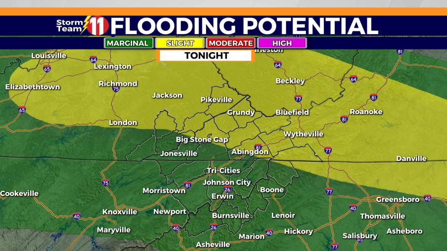
In light of the heavy rains recently, we’ve been placed under a low to medium risk for flash floods overnight. Since it will be dark, it’s crucial to stay alert while driving, as flood waters can be hard to detect. If you come across flood waters, remember to turn around, don’t risk it!

The Storm Team 11 Forecast predicts a mild and humid night with a 50% chance of scattered showers and thunderstorms, particularly in southwest Virginia. Expect partly cloudy skies with areas of dense fog forming where rainfall occurred today. Temperatures will drop to a low of 71 degrees.


Monday will bring partly cloudy skies with hot and humid conditions, alongside a 50% chance of scattered showers and thunderstorms. With more rain expected, the whole viewing area is under a low flash flood threat. The high temperature will reach 90 degrees, feeling almost like 100 degrees.


Partly cloudy skies with a passing shower or t-storm are forecast for Monday night with a low of 70 degrees.
Tuesday will be partly cloudy and hot with a 40% chance of scattered showers and thunderstorms. The high will be 93 degrees, with a feels-like temperature of nearly 100 degrees. Partly cloudy skies are forecast for Tuesday night, with a chance of scattered showers or thunderstorms. The low will be 71 degrees.


Partly cloudy skies are forecast for Wednesday with a 40% chance of scattered showers and thunderstorms. The high will be hot at 92 degrees, with a feels-like temperature of nearly 100 degrees. Wednesday night will feature scattered showers and thunderstorms. The low will be 71 degrees.


Thursday, the ridge of high pressure is expected to break down, allowing better rain chances to move into the region. The high will be near 88 degrees with a 70% chance of scattered showers and thunderstorms. Showers and thunderstorms will remain likely Thursday night under mostly cloudy skies. The low will be 68 degrees.

Scattered showers and thunderstorms will remain into Friday. The chance of rain will be 50% and the high will be 83 degrees. Showers and thunderstorms will continue into Friday night under mostly cloudy skies. The low will be 66 degrees.

Saturday will be partly cloudy and cooler. A few showers will be possible through the day. The high will be 81 degrees with a 30% rain chance.
The cooler weather will stick into next Sunday with a 30% chance of scattered showers. The high will be around 82 degrees.
Have a great night and stay weather aware.