

Hurricane Erin dramatically intensified and became a major storm over the Atlantic, just north of the Caribbean, on Saturday. In a swift transformation, it upgraded from a tropical storm to a hurricane within one day.
Marking the first Atlantic hurricane of 2025, Erin reached Category 5 status before slightly weakening to a Category 4 storm, packing maximum sustained winds of 150 mph (240 kph), as reported by the National Hurricane Center in Miami.
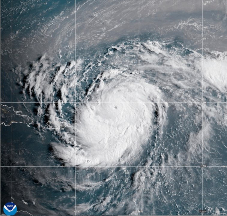
The eye of Erin was situated approximately 150 miles (235 kilometers) northeast of San Juan, Puerto Rico, moving westward at a speed of 15 mph (24 kph).
While the hurricane’s center was not expected to strike land, it threatened to dump flooding rains on islands in the region.
Mike Brennen, the director of the National Hurricane Center in Miami, described Erin as a “very powerful hurricane,” noting its rapid intensification, which saw wind speeds jump by 60 mph (96 kph) in roughly nine hours.
The Hurricane Center noted that Erin is expected to gradually weaken owing to increasing wind shear, though it is likely to maintain its status as a major hurricane through late next week.
Erin close enough to land to trigger flooding, landslides
The storm’s center was forecast to remain at sea, passing north of Puerto Rico, according to the National Hurricane Center.
But tropical storm watches were issued for St. Martin, St. Barts and the Turks and Caicos Islands.
The Hurricane Center warned that heavy rain in some areas could trigger flash flooding, landslides and mudslides.
In San Juan, residents and visitors went about their usual activities on Saturday, engaging in walking, exercising, and shopping. Restaurants remained bustling, and despite advisories to steer clear of the beaches, some ventured into the coastal waters, though parents were cautious, preventing their children from swimming.
Sarahí Torres and Joanna Cornejo, who were visiting from California for a Bad Bunny concert, said they decided to go to the beach and wade into the water because the skies appeared calm.
“The weather looked fine, so we came out,” Torres said.
Power was knocked out to about 130,000 customers in Puerto Rico.
The U.S. government deployed more than 200 employees from the Federal Emergency Management Agency and other agencies to Puerto Rico as a precaution. Puerto Rico Housing Secretary Ciary Pérez Peña said 367 shelters were inspected and ready to open if needed.
Meanwhile officials in the Bahamas prepared some public shelters as a precaution as they urged people to monitor the hurricane.
“These storms are very volatile and can make sudden shifts in movement,” said Aarone Sargent, managing director for the Bahamas’ disaster risk management authority.
Though compact, with hurricane-force winds extending 30 miles (45 km) from its center, Erin was expected to double or even triple in size in the coming days.
Powerful rip currents could affect the U.S. East Coast from Florida to the mid-Atlantic next week, despite the eye of the storm forecast to remain far offshore, Brennan said.
An ‘incredible’ race from tropical storm to Category 5
Hurricane specialist and storm surge expert Michael Lowry said Erin gained strength at a pace that was “incredible for any time of year, let alone Aug. 16th.”
Lowry said only four other Category 5 hurricanes have been recorded in the Atlantic on or before Aug. 16.
The most powerful storms tend to form later in the year, with the hurricane season typically peaking in mid-September.
In October 2005, Hurricane Wilma rocketed from a tropical storm to a Category 5 in less than 24 hours, according to National Hurricane Center advisories from that time. Wilma weakened to a Category 3 hurricane before striking Florida. And in October 2007, Hurricane Felix took just over a day to go from a tropical storm to Category 5.
Including Erin, there have been 43 hurricanes that have reached Category 5 status on record in the Atlantic, said Dan Pydynowski, senior meteorologist at AccuWeather, a private forecasting company.
“They’re certainly rare, although this would mark the fourth year in a row that we’ve had one in the Atlantic basin,” Pydynowski said. Conditions needed for hurricanes to reach such strength include very warm ocean water, little to no wind shear and being far from land, he said.
Scientists say warming climate linked to storms strengthening faster
Scientists have linked rapid intensification of hurricanes in the Atlantic to climate change. Global warming is causing the atmosphere to hold more water vapor and is spiking ocean temperatures, and warmer waters give hurricanes fuel to unleash more rain and strengthen more quickly.
Storms that ramp up so quickly complicate forecasting for meteorologists and make it harder for government agencies to plan for emergencies. Hurricane Erick, a Pacific storm that made landfall June 19 in Oaxaca, Mexico, also strengthened rapidly, doubling in intensity in less than a day.
Erin is the fifth named storm of the Atlantic hurricane season, which runs from June 1 to Nov. 30 and is expected to be unusually busy. Six to 10 hurricanes are predicted for the season, including three to five reaching major status with winds of more than 110 mph (177 kph).
___
Bynum reported from Savannah. Georgia. Associated Press writers Isabella O’Malley in Philadelphia and Ivelisse Rivera in San Juan contributed.
___
The Associated Press’ climate and environmental coverage receives financial support from multiple private foundations. AP is solely responsible for all content. Find AP’s standards for working with philanthropies, a list of supporters and funded coverage areas at AP.org.