
In Savannah, Ga., Labor Day offered splendid weather with afternoon highs only reaching the lower 80s and minimal humidity creating pleasant conditions.
We did have a strong breeze throughout the day and will remain strong again for Tuesday.
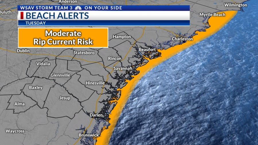
Dangerous rip currents and high surf is expected for the Georgia and South Carolina beaches because of the strong onshore wind.

Tuesday afternoon is anticipated to bring a blend of clouds and sun, with temperatures rising to the mid to upper 80s while keeping humidity at bay.

A weather system currently over the nation’s mid-section is expected to facilitate the development of a few showers and thunderstorms by Wednesday and Thursday as it moves through the southeast.
As the week concludes, expect hot and humid weather on Friday, extending into the weekend with afternoon highs climbing back into the lower 90s. Early next week could bring more thunderstorms.


September 1 begins the meteorological fall, a period known for cooling temperatures. The average high starts at 89°F but decreases to 83°F by the month’s end.
Very hot days are still possible. The all-time record high for September is 102°F was set on 4th in 1925.

TRACKING THE TROPICS
The National Hurricane Center continues to monitor a tropical wave for potential development that is moving off of the West coast of Africa.
It has a medium (60%) chance of becoming a tropical depression or tropical storm over the next five to seven days.
The system’s path indicates a conducive environment for gradual development, with long-term forecasts showing it moving west before shifting to a west-northwest direction over the next week.
There is no threat to the U.S. at this time.