
A significant portion of Queensland is gearing up for an intense weekend as severe weather conditions loom.
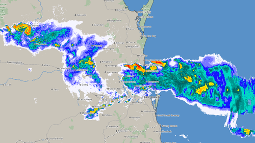
Recently, a line of severe thunderstorms moved through south-east Queensland, prompting a cautionary alert from the Bureau of Meteorology that this was only the start.
The tumultuous weather began on Friday, targeting the Darling Downs area, situated to the west of Brisbane, before gradually advancing towards the Gold Coast.
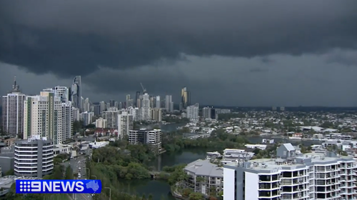
“We’ve really been hit hard here on the Gold Coast,” shared 9News Queensland’s weather specialist, Luke Bradnam, during a 6 pm report (7 pm AEDT).
“Currently, the city and its northern suburbs are experiencing the storm’s most intense phase,” he noted.
The storm system is progressing northeastward, heading towards the Sunshine Coast.
Some of the biggest rainfall was at Mitchelton, in Brisbane’s north, where 48 millimetres fell in just 30 minutes to 6.20pm, and at Wallumbilla, more than 400 kilometres west of Brisbane, where 41 millimetres fell at almost the same time.
The BoM said Clontarf, in Moreton Bay, copped hail up to 4 centimetres just after 6pm.
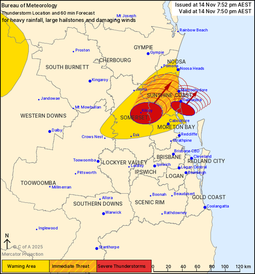
Wind gusts of 91km/h were recorded at Nambour on the Sunshine Coast at 8.31pm.
The storms were tracking towards the ocean but still threatened big downpours and damaging conditions, the BoM said.
“Severe thunderstorms are likely to produce heavy rainfall that may lead to flash flooding and damaging winds in the warning area over the next several hours,” it said.
And the outlook for the weekend does not get much better.
The bureau has warned of scattered showers and thunderstorms across the state, with the potential for severe thunderstorms with heavy rainfall, damaging wind gusts, and large hail in south-east Queensland.