

Central Florida is bracing for another day of dangerous heat and stormy weather, with forecasters expecting the unsettled summertime pattern to hold through Father’s Day weekend.
A Heat Advisory remains in effect Friday from 11 a.m. to 7 p.m. Heat index values are projected to reach between 108 and 111 degrees, while afternoon temperatures rise into the mid-90s. Combined with high humidity, conditions will feel significantly hotter than the thermometer shows.
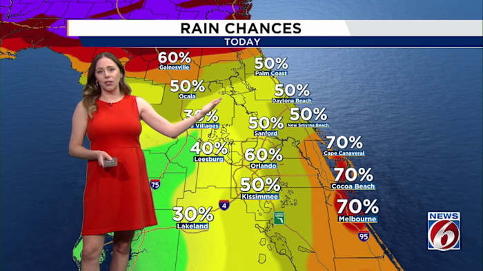
Storm chances are also expected to build through the afternoon as the east and west coast sea breezes collide. Rain and thunderstorm coverage is forecast to range from 40 to 70 percent across much of East Central Florida.
Some of those storms could turn strong to severe, particularly later in the day and into the evening. Forecasters say the primary hazards include damaging wind gusts of up to 60 mph, frequent lightning, small hail, and torrential downpours. Rainfall totals of 1 to 2 inches could fall quickly in some spots, while isolated areas may pick up 3 to 5 inches if storms repeatedly track over the same location.
The region is under a Marginal Risk, or Level 1 out of 5, for severe storms. Brevard County is also under a Marginal Risk, Level 1 out of 5, for excessive rainfall.
Looking ahead to the weekend, the same mix of oppressive heat and scattered afternoon storms is expected to remain in place across the area.
The active pattern continues into Saturday, when storm coverage increases to 50 to 80 percent. Another round of strong storms will be possible, bringing gusty winds, frequent lightning, heavy rain, and localized flooding concerns.
Storm chances decrease slightly on Father’s Day, but scattered afternoon and evening storms remain in the forecast. Temperatures will continue to run above normal through the weekend, with highs in the low to mid 90s and heat index values topping 100 degrees.
NEXT WEEK
Looking ahead to next week, rain chances gradually decrease as high pressure builds over the eastern Gulf. However, daily afternoon storms and above normal temperatures will remain part of the forecast.


