
Severe storms sweeping across several states have prompted officials to urge people to avoid driving, warning that rapidly rising floodwaters could turn roadways into deadly traps.
The NWS cautioned in a statement: “Torrential rainfall is occurring with these storms, and may lead to flash flooding. Do not drive your vehicle through flooded roadways.”
On Tuesday, the National Weather Service issued severe thunderstorm and flash flood warnings for Arkansas, Kansas, Louisiana, Oklahoma and Texas, as forecasters warned the hazardous conditions are expected to linger for several days.
On the storm system’s eastern flank, meteorologists said parts of Arkansas, Louisiana, Oklahoma and Texas had already recorded as much as three inches of rain by Tuesday morning, with up to four additional inches possible by midday local time.
In Kansas, the same intense system is forecast to produce wind gusts topping 60 mph, along with hail approaching the size of golf balls.
“Hail damage to vehicles is expected. Expect wind damage to roofs, siding and trees,” weather officials said.
AccuWeather also reported that the threat of severe thunderstorms is expected to expand into Colorado, Nebraska and southern Wyoming on Tuesday afternoon, with the sprawling storm system continuing into the overnight hours.
In addition to flash flooding and destructive hail, the strongest storms could also produce isolated tornadoes in the hardest-hit areas.

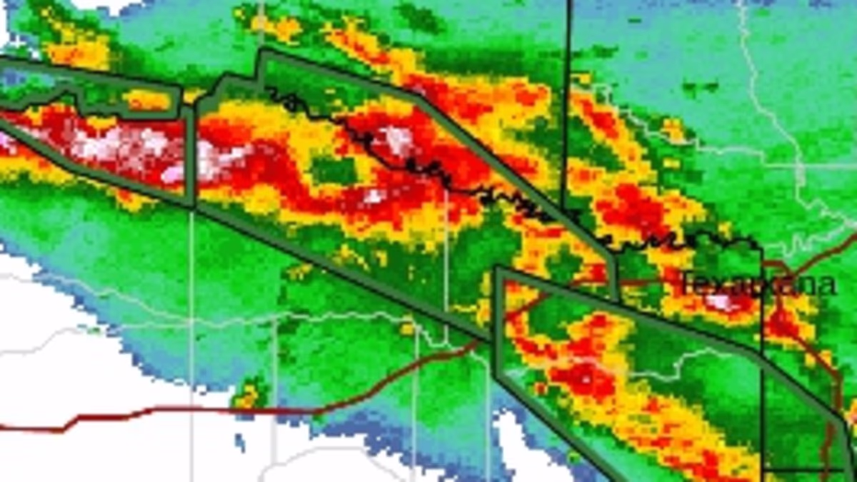
Radar images reveal major storm systems moving across the southern US on Tuesday, June 23

Meteorologists have warned that flash flood and thunderstorms may last across several states through Thursday, June 25 (Stock Image)
AccuWeather meteorologists warned that wind gusts on Tuesday and Wednesday could reach 85 mph, the equivalent of a Category 1 hurricane.
Multiple cities will be in the path of the flooding threats, including Paris, Texas, Shreveport, Louisiana and Norman, Oklahoma.
The storm is expected to hit multiple regions throughout Texas and Louisiana which were just struck by Tropical Storm Arthur days ago.
Forecasters revealed that the week ahead will only see these storms spread across the Plains as storm systems moving in from the Colorado Rockies collides with warm, moist air flowing north from the Gulf Coast.
READ MORE: Stepmum in Bed? Couple Caught Kissing at a Multi-Million-Dollar Mansion
The warm air will add the fuel thunderstorms need to potentially create extreme systems known as supercells, which regularly bring large hail and tornadoes to the South and Midwest in the spring and summer.
The storm threat is expected to also affect New Mexico, Mississippi, Alabama, southern Missouri and the Florida Panhandle on Wednesday.
AccuWeather Meteorologist Alex Duffus said in a statement: ‘The focus of severe thunderstorms will shift into the northern Plains and Midwest this weekend. Thunderstorms in this region will pose the risk of damaging winds, hail and even a few tornadoes.’
‘For your protection stay inside a sturdy structure and keep away from windows,’ NWS added.
This is a breaking story. More details to follow.

At least five states are in the path of extreme thunderstorms bringing tornadoes, hail and flash flooding this week

Pictured: A car submerged in flash flooding in Texas. Weather officials are warning thousands of drivers across five states to avoid the roads Tuesday as flash flooding could cause deadly conditions

Radar maps of the South revealed severe thunderstorms moving into Arkansas, Kansas, Louisiana, Oklahoma and Texas

Pictured: A car being rescued from flash floods in De Kalb, Texas