
Share this @internewscast.com

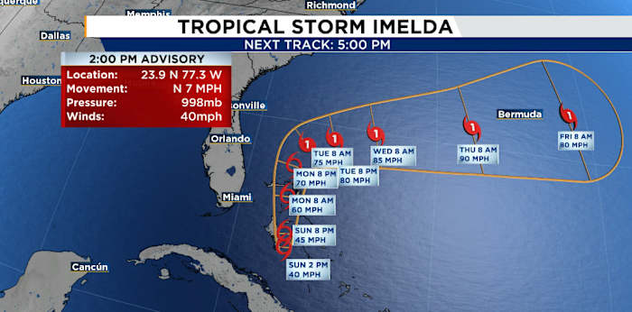
ORLANDO, Fla. – Tropical Depression Nine has become Tropical Storm Imelda as of the National Hurricane Center’s 2 p.m. advisory Sunday.
At that moment, Tropical Storm Imelda was situated around 95 miles west-northwest of the central Bahamas and approximately 370 miles southeast of Cape Canaveral, as reported by the NHC. The storm was recorded to have maximum sustained wind speeds of 40 mph, moving northward at 7 mph.
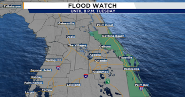
A tropical storm watch is in effect for Florida’s east coast from the Palm Beach/Martin County line to the Flagler/Volusia County line.
[MORE: Tropical storm watch in effect. Here’s what Central Florida can expect]
A quicker northward movement is anticipated later on Sunday and continuing through Monday, according to the advisory. It mentions that the storm’s center is forecasted to travel across the central and northwestern Bahamas through the evening before shifting east-northeastward and distancing itself from the southeastern U.S. by the middle of the week.
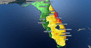
The NHC indicated that tropical-storm conditions might affect the watch area along Florida’s Atlantic coast on Monday. There’s also a warning for potential coastal flooding, with water levels possibly rising up to 1 to 2 feet above the ground from the Volusia/Brevard County line to Santee River, South Carolina, if the surge happens during the next few high-tide cycles.
The tropical storm, along with nearby Hurricane Humberto, is generating swells expected to impact parts of the Bahamas this weekend and extend to the U.S. east coast at the beginning of this week. These conditions could lead to dangerous surf and rip currents, according to the advisory.
Copyright 2025 by WKMG ClickOrlando – All rights reserved.