Share this @internewscast.com
Prepare for a wild ride in town over the next few days as temperatures swing dramatically. We’re expecting to flirt with record highs before an abrupt shift to cooler-than-normal conditions within 48 to 72 hours.
To say it’s going to be a roller coaster is putting it mildly.
Today offers a brief reprieve with mild temperatures and pleasant overnight conditions. The winds are calmer, providing a slightly warmer feel compared to yesterday.
As the winds die down after sunset, fog is likely to develop overnight. In some areas, particularly near daybreak tomorrow, the fog could become dense. This may impact visibility, so plan your Thursday morning commute accordingly.
Despite the calming winds, rip currents remain a concern along our Atlantic beaches. While the warm weather might tempt you to the shore, exercise caution if you decide to head out to the coast.
As the days unfold, brace yourself for a steady climb in temperatures. If you’ve ever watched “The Price is Right,” think of the game where the hiker steadily ascends until the correct price is guessed – that’s how our temperatures will rise.
Yeah – we’ll be playing the same game with our thermometers!
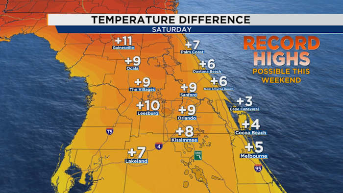
We could see upper 80s and high UV indexes for our Friday and Saturday which is comparable to the traditional weather we’d see in the month of MAY!
Who ordered the DeLorean from Back to the Future? Are we really in that much of a hurry to see summer rolling in?
If you do intend on being out for longer than 20-30 minutes on Friday and Saturday, dress lightly, hydrate, and make sure you’ve got the necessary protection from the sun ready to go. It will indeed feel like a bonified spring if not summertime afternoon, even more so for Saturday.
Then, we’ve essentially hit the top of our roller coaster. Think of Sunday like the brief pause you take when facing straight down out on SheiKra at Busch Gardens.
Come Monday and into Tuesday our temperatures fall flat back into what feels like winter just powered back up again.
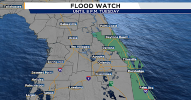
We’ll awake on Tuesday to feels like temps right around or at freezing. We could also see some beneficial rain as the cold front arrives, sliding across the peninsula late Sunday into Monday.
Now, I’d mentioned winter maybe being over for Central Florida. Don’t let the chill fool you. We’re actually seeing a lot more spring action than meets the eye, and I promise I’m not making a Transformers reference.
We’ve hit the time of the year where Spring will attempt to dominate the local weather and much of the south altogether. But winter is holding on for dear life, which is why the two tend to clash during this point called “transition season”.
These little doses of cold air from up north will likely become more frequent. But they won’t be long-lasting. This time next week we’ll already start to warm up into the low to mid 70s right after that slap of wintry bliss.
Copyright 2026 by WKMG ClickOrlando – All rights reserved.