ORLANDO, Fla. – Central Florida is facing another sweltering summer afternoon Monday, with oppressive heat expected to build before scattered storms move in later in the day.
MONDAY
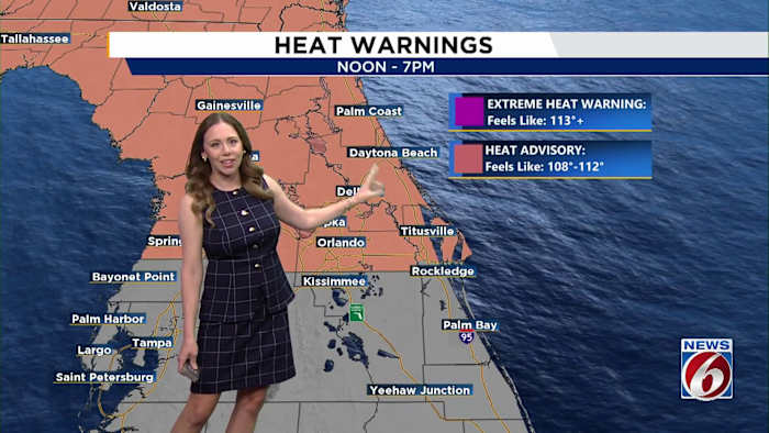
A Heat Advisory will be in place from noon through 7 p.m. for Marion, Flagler, Lake, Volusia, Seminole, Orange and northern Brevard counties. In those areas, the heat index is forecast to soar to between 108 and 110 degrees.
Actual temperatures are expected to rise into the mid- to upper 90s away from the coast, while communities along the immediate shoreline should remain in the lower 90s. The most intense heat is likely near and north of the Interstate 4 corridor, making Monday the hottest day of the week.
By afternoon, the sea breeze will help spark scattered showers and thunderstorms, with rain chances running around 50% to 60%. The highest storm coverage is expected across inland areas late in the afternoon and into the early evening.
Some storms may turn strong, bringing frequent lightning, heavy downpours and wind gusts that could reach up to 50 mph.
TUESDAY
Rain chances will climb Tuesday as a weak front drifts closer to North Florida, boosting shower and thunderstorm coverage to 70% to 80%. Northern and interior sections of Central Florida are expected to see the most activity. Temperatures should dip slightly, though feels-like readings will still top 100 degrees.
LATE WEEK
The typical summer pattern continues through the rest of the week, with daily afternoon storms, highs in the low 90s, and muggy conditions sticking around into the 4th of July weekend.