

ORLANDO, Fla. — A poorly organized area of low pressure tracking along the Middle Texas coast is raising serious flooding concerns across parts of the Gulf Coast, even if it never fully develops into a named system.
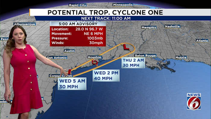
In its 5 a.m. update Wednesday, forecasters said Potential Tropical Cyclone One was positioned just southwest of Port O’Connor, Texas. The system was carrying maximum sustained winds of 30 mph and moving northeast along the Texas coastline.
Current projections show the disturbance heading inland by Wednesday afternoon, likely crossing into eastern Texas or southwestern Louisiana.
Although there remains a narrow chance the system could briefly strengthen into a tropical storm, that scenario is becoming increasingly unlikely. Forecasters say the disturbance may never officially reach tropical system status before weakening and dissipating early Thursday.
Regardless of whether it earns a formal designation, the system’s most significant threat is heavy rain and the potential for dangerous flooding in vulnerable Gulf Coast communities.
IMPACTS
Regardless of whether it develops into Arthur, the impacts will be significant.
The biggest concern is heavy rainfall and life threatening flash flooding from the Upper Texas Coast eastward through Louisiana, Mississippi, Alabama, western Georgia, and the Florida Panhandle.
Rainfall totals of 5 to 10 inches are expected through early Friday, with isolated amounts approaching 20 inches possible in some locations.
Tropical storm warnings remain in effect from Sabine Pass, Texas, to Morgan City, Louisiana, where tropical storm conditions are expected Wednesday.
A few tornadoes could develop through Thursday across southern Louisiana, Mississippi, Alabama, and the western Florida Panhandle.


