
SAVANNAH – Ga. () — The hot and very humid pattern from the weekend continued into Monday.
Highs for most locations were in the upper 90s. Heat index values for most locations were over 108°F which prompted heat advisories.
Scattered showers and storms have helped to lower the temperatures for the evening. Rainfall amounts exceeded 2-3 inches along the coast and areas south of the Altamaha River, where the strongest storms had formed.
A LOOK AHEAD
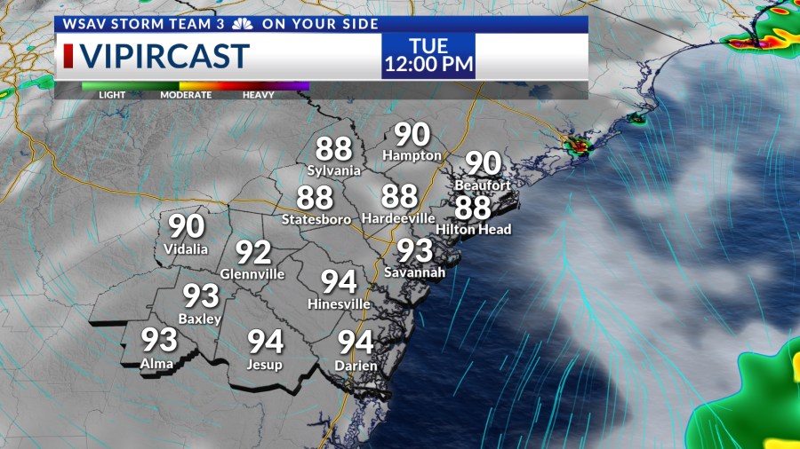
Storms are expected to become more widespread starting Tuesday. Heavy rain and scattered storms are set to develop in the early afternoon and persist intermittently throughout the evening.


There is a chance that a few storms may become strong to severe with damaging wind gusts being the primary concern.
Afternoon highs will warm into the low to mid 90s ahead of the storms which will provide ample fuel for some strong storms.

The likelihood of storms will remain high on Wednesday, as deeper tropical moisture moves in, supported by some upper-level tropical energy located east of Florida. As the week progresses, rain chances will slightly decrease.
However, we still expect scattered storms for Thursday and Friday. Afternoon highs look to be a little lower because of a weak frontal boundary that will move through the Coastal Empire and Lowcountry.
The weekend forecast looks to be mainly dry and hotter though. A few isolated showers or storms are expected along with highs getting back into the mid 90s.
Heat index values will be over 105°F at times over the weekend and into next week.
TRACKING THE TROPICS
There is a weak tropical wave (Invest 94L) that is located in the central Atlantic. It is not very well organized and is showing signs that it is struggling to maintain its status as a tropical wave.
It is interacting with some dry air located to the west and some wind shear which both will help inhibit storm development.
This tropical wave is moving toward the Caribbean Sea and has a LOW (10%) chance of developing into a tropical depression or tropical storm over the next five to seven days.
There is no threat to the U.S. at this time from any tropical systems.