
SAVANNAH, Ga. () — Friday was a hot and then stormy day, just as expected.
Temperatures in the afternoon soared to the mid to upper 90s, accompanied by higher heat index values. This increased heat intensity contributed to the formation of a few robust and severe storms during the early evening hours.
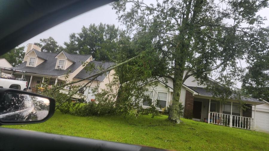
One severe storm that passed over Richmond Hill may have caused a microburst, resulting in significant tree damage in the Piercefield neighborhood. A microburst involves a swiftly descending air column within a thunderstorm that can generate damaging wind gusts at ground level.
Some microbursts can produce winds in excess of 100 mph. Richmond Hill likely had wind speeds in excess of 50 or 60 mph with Friday’s storm.
-

Jay Henyecz, Richmond Hill Piercefield neighborhood -
Jay Henyecz, Richmond Hill Piercefield neighborhood -
Jay Henyecz, Richmond Hill Piercefield neighborhood -
Jay Henyecz, Richmond Hill Piercefield neighborhood -
Jay Henyecz, Richmond Hill Piercefield neighborhood -
Jay Henyecz, Richmond Hill Piercefield neighborhood -
Jay Henyecz, Richmond Hill Piercefield neighborhood -
Jay Henyecz, Richmond Hill Piercefield neighborhood -
Jay Henyecz, Richmond Hill Piercefield neighborhood -
Jay Henyecz, Richmond Hill Piercefield neighborhood


A LOOK AHEAD
A cold front is slowly moving into the southeast Friday evening. It will lead to more widespread rain and thunderstorms over the weekend.

Both Saturday and Sunday will also feature below-normal highs as a result of the frontal boundary and the high rain chances.
Rainfall totals are expected to range from 2 to 4 inches in many areas, with some locations possibly experiencing higher amounts. There’s a potential for flash flooding in the Coastal Empire and Lowcountry, particularly in regions with inadequate drainage.


Exercise caution if you find yourself caught in these intense downpours, as there could be water pooling on the roads and limited visibility. Anticipated afternoon highs for Saturday and Sunday will be in the mid to upper 80s.
Starting Monday, rain chances will begin to decrease. However, scattered showers and storms are still anticipated from Monday to Friday. Afternoon highs will stay below normal, ranging from the mid to upper 80s to lower 90s.
The normal or average high for the first week of Augusts is 92°F.

TRACKING THE TROPICS
At present, the National Hurricane Center is not tracking any areas for potential tropical development. However, it may be necessary to keep an eye on the northern Gulf or the Atlantic just off the southeastern U.S. coast for possible gradual development next week.
Stalled frontal boundaries are often places where tropical depressions or tropical storms can develop. There currently is no threat to the U.S. at this time.
August is normally when we begin to see the tropical Atlantic start to become more active based the number of tropical systems.