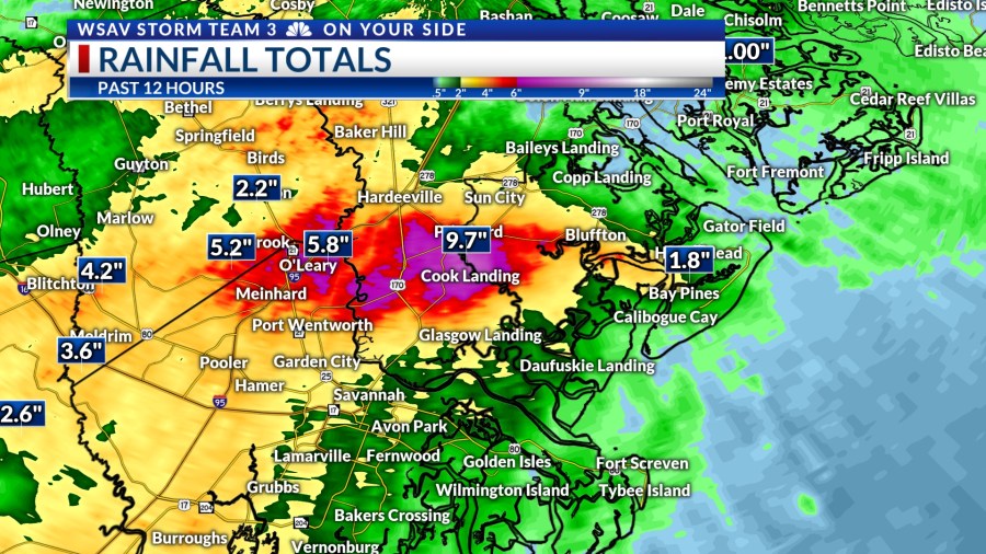

SAVANNAH, Ga. () — Thursday afternoon was very stormy as expected. We had widespread rain and storms all around the Coastal Empire and Lowcountry.
Heavy rain was an issue with VIPIR Radar estimating that some portions of Jasper and Beaufort County receiving over 8″ of rain.


A line of severe storms passed through Chatham, Bryan, and Jasper County, bringing wind gusts exceeding 40 mph. At around 5:30 p.m., Savannah-Hilton Head International Airport reported a wind gust of 49 mph.
Numerous power outages were reported, especially in Chatham and Jasper County.
A tornado warning was briefly issued for a rotating cell near Limehouse in south central Jasper County. As of Thursday evening, no funnel clouds or tornado damage have been reported.
A LOOK AHEAD
Conditions heading into early Friday morning will be mainly dry, warm and humid. Overnight lows will be in the mid to upper 70s.
Temperatures are set to rise rapidly in the morning, reaching the upper 80s to lower 90s before lunchtime. Most areas will see highs reaching the low to mid 90s.
Showers and storms will begin to develop after 1 p.m. and will continue on and off into the early evening.
Heavy rain is expected at times. High rainfall rates may lead to localized flooding in areas with poor drainage.


A few storms may become strong to severe in the afternoon with gusty wind as the primary concern. However, the overall severe risk is very low.
A slightly greater risk for severe weather will encompass the Augusta area and into the Midlands of South Carolina.
A drier and hotter pattern will be in place by the weekend. Rain and storm chances will be minimal. If you do have outdoor plans on Saturday and Sunday, keep an eye to the sky because there is a chance that a few isolated showers or storms may develop.

High temperatures over the weekend will top out in the mid to upper 80s with heat index values over 105°F at times. Be sure to stay cool and hydrated while taking plenty of breaks if you will be engaging in outdoor activities.


THE TROPICS
The Atlantic basin remains quiet from any tropical development. There are no areas to watch for potential development over the next five to seven days.
Some long-range global forecast models continue to hint at the possibility of something organizing in the northern Gulf within the next 8 to 14 days.
Water temperatures are in the mid to upper 80s and would support development.
There is no threat to the U.S. from any tropical systems at this time.