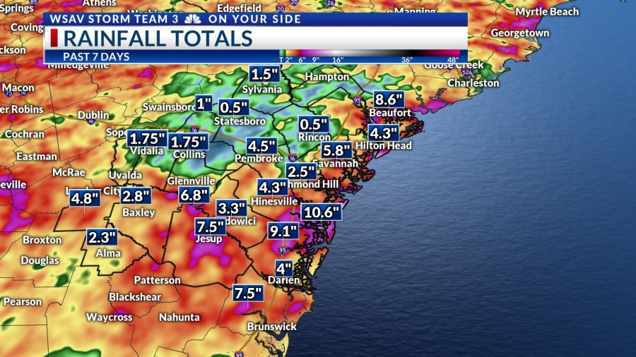
SAVANNAH, Ga. () — After a wet and cooler weekend in the Coastal Empire and Lowcountry, the new week started out with similar conditions.
Pockets of heavy rain were tracking across the region for much of Monday afternoon.
While most of the area didn’t experience significant rainfall totals, a few spots saw quite heavy precipitation. According to VIPIR Radar, some parts of interior Bryan County were drenched with over 3 inches of rain on Monday afternoon.
Since last Friday, however, many locations have accumulated 5 inches of rain with more expected this week, leading to some flooding issues over the weekend, particularly on Saturday and Sunday.

A LOOK AHEAD
Additional showers and storms are anticipated throughout the week as a stalled frontal boundary persists over the southeast. This boundary will facilitate the influx of Gulf moisture, thereby causing occasional heavy rainfall.
The ongoing issue of heavy rainfall is likely to persist throughout the week. Flash flooding could occur in areas with inadequate drainage systems as the ground has become saturated from recent heavy rains.
Rainfall totals between Tuesday and the weekend may be up to 2-3″. Locally higher amounts are possible.

Timing for rain and storms will primarily be in the afternoons Tuesday through the weekend.
Although, night-time passing showers and storms are still possible due to the ample moisture entering the region and the stationary boundary continuing to spark storm development.


One advantage of this unsettled weather pattern is that it will help maintain afternoon temperatures below normal. The forecast suggests that high temperatures will linger in the mid to upper 80s over the next few days.
Conditions will gradually warm later in the week and next week as rain and storm chances may begin to backoff. Next week is expected to be a little drier with highs in the low to mid 90s.


TRACKING THE TROPICS
The tropics started to become more active over this past weekend. An area of disturbed weather north of Bermuda became Tropical Storm Dexter on Sunday. It is a weak tropical storm with sustained 45 mph wind and gusts up to 65 mph.
This system is forecast to maintain strength over the next several days. Dexter is expected to begin weakening by the weekend. This system is moving away from the U.S. and poses no direct threat to any land.


The National Hurricane Center is also monitoring two other systems for potential development. One area that is highlighted is an area of cloudiness just off of the Georgia and South Carolina coasts.
This broad area of low pressure is associated with the stalled out frontal boundary draped over the southeast. It has a low (30%) chance of becoming a tropical depression or tropical storm over the next five-seven days.
Enhanced rain chances would be our main local concern from this system regardless of development. There is no direct threat to the U.S. at this time.

The third system that is being monitored for potential development is a strong wave that is moving off of the west coast of Africa. Environmental conditions are forecast to support gradual organization and strengthening over the next five-seven days.
This tropical wave has a medium (50%) chance of developing into a tropical depression or tropical storm later this week. Long-range guidance indicated that this system will favor turning to the north into the central Atlantic before impacting the Antilles.
There is no threat to land or the U.S. from this tropical wave at this time.