
Share this @internewscast.com
SAVANNAH, Ga. () — Tuesday afternoon and into the early evening was very active weatherwise.
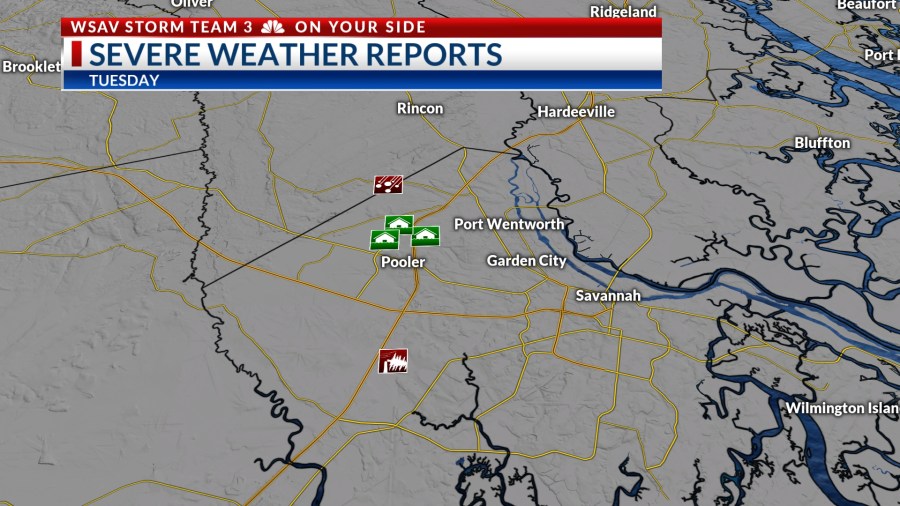
A series of powerful storms emerged, bringing strong wind gusts. At Savannah-Hilton Head International Airport, winds reached 60 mph due to a severe storm.


The same storm caused significant rainfall, with radar estimating over 5 inches of rain in Pooler. Meanwhile, the airport situated just west of Pooler recorded 1.58 inches. Excessive rainfall was also problematic in the Lowcountry.
Portions of Hampton, Jasper, and Beaufort County received over 2″ of rain.

A LOOK AHEAD
More heavy rain at times is expected for Wednesday afternoon. The atmosphere remains very warm and humid which sets us up for high rainfall rates.
While storms on Wednesday might not be as widespread as Tuesday’s, they will still produce heavy rain. Localized flooding remains a concern due to saturated soils and the potential for slow-moving storms.
Temperatures will be in the upper 80s to lower 90s.


Rain chances will remain elevated for Thursday and Friday. The stationary boundary that has been draped across the southeast will remain in place.
Scattered showers and storms are expected both days.
Temperatures are more likely to reach the 90s, although the risk of localized flooding persists, albeit lower than earlier in the week.
Rain chances stay high over the weekend. Additionally, there is a need to monitor an area of low pressure off the coast for possible slow tropical development.
The potential developing low off of the coast may help to enhance weekend rain chances depending on how much moisture it may direct toward or area.
Temperatures will remain in the upper 80s to lower 90s Saturday and Sunday.


TRACKING THE TROPICS
The tropics began to show increased activity over the last weekend. A disturbed weather area north of Bermuda developed into Tropical Storm Dexter on Sunday. As of 5 p.m. Wednesday, it was a weak tropical storm with steady winds of 40 mph and gusts reaching up to 50 mph.
This system is forecast to maintain strength over the next several days. Dexter is expected to begin weakening by the weekend.
Dexter is moving away from the U.S. and poses no direct threat to any land.


The National Hurricane Center is also monitoring two other systems for potential development.
One area that is highlighted is an area of cloudiness just off of the Georgia and South Carolina coasts. This broad area of low pressure is associated with the stalled out frontal boundary draped over the southeast.
It has a medium (40%) chance of becoming a tropical depression or tropical storm over the next five-seven days. Enhanced rain chances would be our main local concern from this system regardless of development.
High surf and rip currents will be possible later this week and into the weekend. There is no direct threat to the U.S. at this time.

The third system that is being monitored for potential development is a strong wave that is moving off of the west coast of Africa. Environmental conditions are forecast to support gradual organization and strengthening over the next five-seven days.
This tropical wave has a medium (50%) chance of developing into a tropical depression or tropical storm later this week.
Long-range guidance indicated that this system would favor turning to the north into the central Atlantic before impacting the Antilles.
This system poses no threat to the U.S. right now.