The east coast of Australia is set to experience a week of significant rainfall, with potential flooding concerns looming.
The Bureau of Meteorology (BoM) has issued warnings for an “extended period of wet and rainy weather” across the east coast, stretching from south-east Queensland down to the Illawarra region south of Sydney. Rainfall is anticipated to reach between 50 to 100mm, peaking on Tuesday and being most widespread on Wednesday and Thursday, before tapering off over the weekend.

Certain sections of the northern rivers have flood warnings in effect, and the NSW State Emergency Service is advising northern communities to prepare for possible flooding.

An orange and white truck parked on a road. The double lane markings are in the centre, leading into a flooded section.

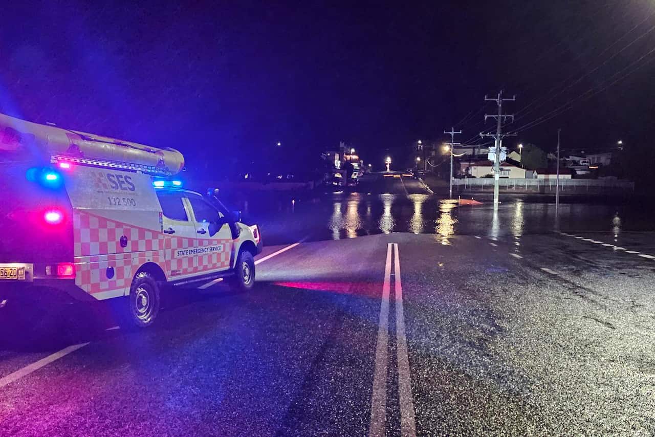
The NSW State Emergency Service is cautioning northern NSW communities about the flood risks in areas still saturated from prior rains. Source: AAP / PR HANDOUT

Flood warnings for northern NSW

Senior meteorologist at the BoM, Dean Narramore, says the areas of most concern for potential flooding are from Coffs Harbour and Grafton through to Port Macquarie.
“Definitely right now our focus is really on the northern rivers, the mid-north and the Hunter, as well as communities in the north-west out towards Tamworth, where we have flood watches and flood warnings current,” he told SBS News.

An active flood watch is already in place for the Namoi and Barwon Rivers in north-west NSW.

“In inland areas, so the Namoi and the Peel River, we’ve already got minor flooding going on right now and so additional rainfall in these areas will lead to renewed rises around the rivers of Hastings, Macleay and the Coffs Harbour areas.”
The NSW State Emergency Service (SES) is warning residents in these catchments to understand their flood risks and have an emergency plan in place. Assistant commissioner Colin Malone says that even though there is uncertainty around where the heaviest rain might hit, it won’t take much for some areas to experience flash flooding or renewed riverine rises.
“We know that catchments in northern NSW are saturated from recent weather events and will respond quickly to this rainfall,” he said.
“Thunderstorms could also cause localised heavy falls, bringing a risk of flash flooding.”

The BoM and the SES advise anybody impacted by flooding not to drive, walk, swim or play in floodwaters and to stay away from flooded areas.

More rain on the way for Sydney

“By the end of this week you could easily see a monthly total of over 300mm for Sydney,” Narramore said.

As of Monday afternoon, Sydney is predicted to see a rainfall maximum of 25mm on Tuesday, increasing to 45mm on Wednesday and 35mm on Thursday. The rain is expected to taper off slightly on Friday before clearing by the weekend.

However, Narramore says it will be a brief reprieve with another weather system potentially on the way next week.
“We’re a bit stuck in this weather pattern,” he said.

“Unfortunately, if you dislike wet and rainy conditions, this weather pattern is likely to persist. Not only in Sydney but across eastern Australia, we’re anticipating above-average rainfall throughout September, October, and November.”

Coldest night of the year

On Sunday night, a dry polar airmass over southeastern Australia, combined with clear skies, resulted in the coldest night of the year so far.

Thredbo Top Station recorded a minimum of -13.2C, while Mt Hotham in Victoria recorded -7.6C.
The last time NSW experienced temperatures like this was in 2018. The coldest temperature ever recorded in Australia was at Charlotte Pass in the Snowy Mountains in 1994 which sunk to a chilly -23C.

You May Also Like

How a Blue-Tongued Lizard Became a Symbol of Reconciliation at a Local School

Stay informed with our reliable daily news updates and in-depth analyses delivered…

Kuwait Airport Shuts Down Amid Rising Tensions and Drone Strikes in Gulf Region

In brief The US military attacked Iran’s Qeshm Island, saying the strikes…

Australian Researchers Discover Clues to the Milky Way’s Ancient Beginnings

In brief CSIRO scientists are helping map the origins of the Milky…

Israel and Lebanon Reach Conditional Ceasefire Agreement: What You Need to Know

In brief Israel and Lebanon have agreed to a conditional ceasefire in…

I’ve Inherited the Gene Behind My Mother’s Greatest Fear

Welcome to your go-to destination for keeping abreast of the latest happenings…
Daryl Mitchell was England's nemesis four years ago, scoring a century in all three Tests - but still ended up on the wrong side of a series whitewash

Daryl Mitchell Thrilled by New Zealand’s Bowling Prowess as Black Caps Target England, Aiming to Match Bradman and Dad’s World Cup Triumphs

It’s been four years since New Zealand’s last Test tour of England,…

CSIRO Announces Substantial Workforce Reductions Amid Increased Scientific Expenses

IN BRIEF Almost 100 roles in the environmental research unit will be…
Named the Mangatangi Fault, the fault line runs alongside the Hunua Ranges in South Auckland, close to the city of Auckland

Scientists Identify Active Fault Line in Auckland, Warn of Potential 6.8 Magnitude Earthquake in New Zealand

When most people think of the ‘Big One,’ their minds usually drift…
Haiti forward Ruben Prividence celebrates after scoring the opening goal in Florida

Scotland Fans Beware: Haiti’s World Cup Team Packs a Surprising Punch

Following a confident 4-1 triumph over Curacao at Hampden last weekend, Steve…