Share this @internewscast.com
New South Wales faces another possible round of floods this week as a “long-lived” rain event continues.
The eastern coastline, stretching from the Illawarra region to the Hunter region, received rainfall amounts ranging from 20mm to 30mm yesterday. Point Perpendicular, situated at the northern entrance of Jervis Bay, recorded the highest total at 65mm.
Increasing rain is also expected today, moving inland over the Central West and Northern Tablelands this afternoon.
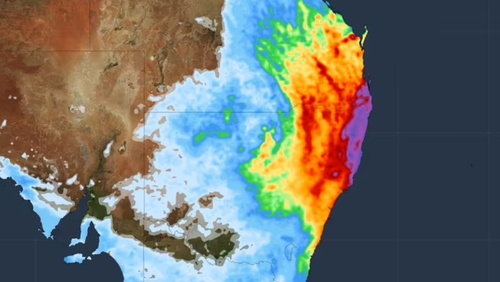
The system is also expected to bring rain to south-east Queensland, including the Darling Downs.
Helen Reid from the Bureau of Meteorology mentioned that although the daily rainfall amounts might not seem significant, the “prolonged nature” of this weather system is likely to result in “quite large” cumulative totals by week’s end.
“The rain this week is concerning for NSW because of how wet it’s been in recent weeks,” she said.
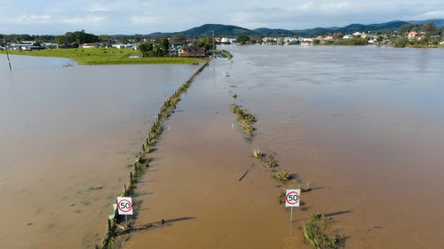
In many of the affected areas, the ground is already too saturated to take in more rain, as much of eastern New South Wales has already experienced rainfall three to four times the average for August this month.
Flood watch warnings are in place, and anybody living on or near a waterway in the rain-affected regions is urged to keep an eye on updates.
Rainfall is anticipated to be most intense on Wednesday and Thursday, with the possibility of the NSW Mid North Coast experiencing 24-hour totals exceeding 100mm, according to Reid.

The fashion icon who kept sinister connections
The rain event is set to ease on Friday, with the system pulling back toward the coast.
Skies are expected to be fully clear by Saturday, Reid said.