
Share this @internewscast.com
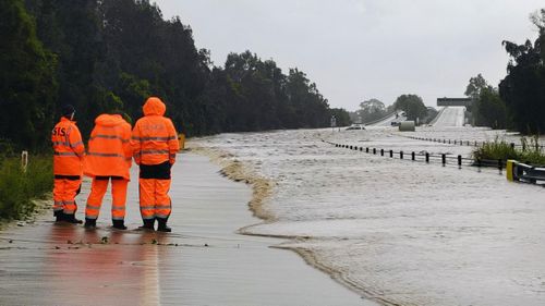
The SES is today urging residents in northern and north-western NSW to prepare for possible flooding as the downpour persists.
A flood watch has been announced for sections of the Mid North Coast, Hunter, and North West Slopes, with the anticipation of minor to moderate flooding from later today, and a possibility of isolated major flooding.
Minor to moderate flooding is also possible in the Hunter and Colo River catchments from tomorrow morning.
He urged residents in impacted areas to have a flood emergency plan in place before waters rise.
Flood warnings from the SES remain for areas in western NSW, as water levels caused by an earlier coastal low-pressure system this month continue to travel downstream.
A total of 24 warnings have been issued for communities to stay informed about possible flooding.
Residents are being reminded to never drive through floodwaters.
The downpour across the east coast is forecast to intensify from today, with a warning of thunderstorms and high winds in many parts.
Sydney is heading for a maximum rainfall of 35mm today, with a maximum of 45mm forecast for tomorrow.
Wind strengths will also increase over the coming hours.
The bureau has issued a strong wind warning for the Macquarie and Hunter coasts from tomorrow.
Meanwhile, the drenching over south-eastern Queensland is forecast to continue for the next two days.
A trough advancing eastward across the state’s southern interior is moving into the southeastern areas, bringing with it chances of thunderstorms along the coast, Wide Bay and Burnett, as well as the southern interior.
Brisbane is forecast to receive a maximum rainfall of 35mm today and tomorrow.
The downpour is set to ease on Friday, with the system pulling back toward the coast.