
By mid-afternoon, the city experienced temperatures soaring to 26.9 degrees, significantly surpassing the typical May peak of 14.6 degrees by over 12 degrees.
These unprecedented temperatures were largely driven by warm north-westerly winds, which also led to several other May temperature records being shattered.
In the south-western region of the state, Warrnambool witnessed temperatures climbing to 28.3 degrees by 1:23 pm.
Hay also exceeded its May record, hitting 29.2 degrees, beating the old record of 29.1 by a whisker.
Meanwhile, Ivanhoe recorded a high of 29.5 degrees, breaking its previous record of 29.1 degrees.
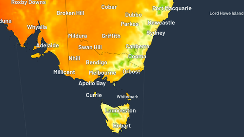
Looking ahead, a low-pressure system is expected to bring a mix of rain, strong winds, and thunderstorms across parts of Australia, persisting through at least the middle of the upcoming week.
Additionally, a cold front is anticipated to gradually advance into Victoria late today and continue its progression into tomorrow.
A cold front is set to slowly cross into Victoria late today and into tomorrow.
The low pressure system is then expected to move over Bass Strait or southern Victoria on Monday, with a cool south-westerly airstream in its wake, according to the Bureau of Meteorology.

A cold front and associated trough will also move into NSW.
The system is set to cross the state between tomorrow and early next week, bringing unsettled weather to southern inland parts of the state.
Residents in the ACT can expect mostly cloudy days with the chance of a shower next week.
Isolated coastal showers will continue in Queensland at least Tuesday as a high pressure system extends over the state from a slow moving high near New Zealand.
South Australian residents can expect a cold front in multiple parts of the state, with isolated showers expected for the west coast district and southern agricultural area.
There will be showers over southern parts of Western Australia until at least Tuesday, along with the chance of a thunderstorm over the western Pilbara tomorrow.
A trough which has moved into the Northern Territory’s south-west is expected to reach the Simpson District by this evening.
Off the back of warmer temperatures, showers are expected to fall in many parts of Tasmania until at least Tuesday.
NEVER MISS A STORY: Get your breaking news and exclusive stories first by following us across all platforms.