
Share this @internewscast.com
According to Weatherzone, sea surface temperatures in the region have soared to a significant 31 degrees Celsius, surpassing the critical threshold of 26.5 degrees necessary for cyclone formation.
“Currently, water temperatures north of Australia are registering about 1 to 2 degrees above average for this time of year, with some areas west of the Top End and north of the Kimberley recording sea surface temperatures as high as 31 degrees,” explained Ben Domensino from Weatherzone.
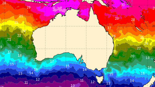
He further noted, “The patch of warm water located northwest of Darwin ranks among the top 10 percent in historical records for this period, indicating that the ocean is well-positioned to support the development of tropical cyclones in the coming weeks.”
The Bureau of Meteorology’s forecast for tropical cyclones suggests there is a slight possibility that a storm could develop as early as next Tuesday.
However, multiple forecast models indicate that the probability increases towards the end of the next week.
“Another contributing factor to the heightened potential for early-season tropical cyclone activity next week is the passage of a tropical atmospheric wave to the north of Australia,” Domensino added.
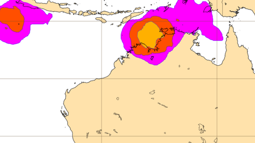
“This wave, called the Madden-Julian Oscillation (MJO), should cause an increase of cloud and thunderstorm activity near northern Australia next week.
“This enhanced storminess can help create low pressure systems that can deepen to become tropical cyclones.”
Despite the overall long odds of a cyclone forming, let alone making landfall in Australia, next week, residents in the country’s north are urged to keep an eye on the Bureau’s weather updates.