
Share this @internewscast.com
Weather experts are growing more certain that a tropical low-pressure system in the Coral Sea, located off northern Queensland, will intensify into a category 1 cyclone before making landfall this weekend.
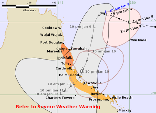
Currently moving slowly, the low—identified as 12U—is projected to advance toward the north tropical coast tonight, potentially crossing between Cairns and Ayr either late Saturday evening or early Sunday morning.
Matt Collopy from the Bureau of Meteorology noted that the likelihood of this system escalating into a cyclone has increased significantly. “Yesterday, the chances were between 20 and 40 percent, but today they’ve risen to between 50 and 60 percent,” he explained.

Collopy further mentioned that tropical cyclones generally require sea surface temperatures of about 26 degrees Celsius to form. “At present, the Coral Sea’s temperatures range from 27 to 28, possibly even 29 degrees,” he observed.
“This means the system has the necessary warm waters to strengthen,” Collopy concluded.
“So the system has what it needs in terms of the warm water to develop.”
Regardless of whether it reaches tropical cyclone intensity, the Bureau of Meteorology is warning the impacts of the heavy rainfall and damaging winds on the already saturated region will be the same.
The Bureau warns the underlying wet soil puts the region at increased risk of tree fall and landslides.
While the cyclone warning is in place for the area from Port Douglas to Tully, including Cairns and Innisfail, a broader severe weather warning is in place for a 1000km stretch of coastline from Hope Vale in the north to Mackay, which will be hit with potentially flooding rain, beginning north of Townsville and then moving south.
“Damaging winds will extend south along the coast throughout the warning area on Saturday, and will turn east to northeasterly south of 12U on Saturday afternoon and evening,” the Bureau said in its latest statement.
“Conditions could begin to ease about the North Tropical Coast north of Innisfail by Saturday evening, but are likely to persist into Sunday over parts of the Herbert and Lower Burdekin and Central Coast and Whitsundays.
”Rainfall totals and warning area is dependent on the development and position of the tropical low.”
Further warnings will be issued as the system moves closer to the coast and residents in warning areas are advised to stay up to date.