
Share this @internewscast.com
For the third day running, fierce storms have battered south-east Queensland, unleashing torrential rain, hail, and strong winds across the region. The tempestuous weather has been particularly intense further inland.
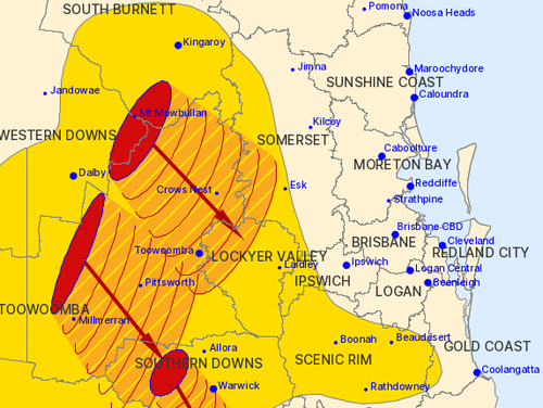
As night fell, severe thunderstorm alerts persisted across areas including the Somerset, Scenic Rim, Western Downs, South Burnett, Toowoomba, and Gold Coast regions.
The Bureau of Meteorology cautioned that these storms are expected to bring with them powerful winds and heavy downpours capable of triggering flash floods.

Reports from weather experts indicated that hailstones had already been spotted near Dalby and Kingaroy, located to the west of the Sunshine Coast, as the storms made their way southeast.
Social media footage captured a trampoline hurled across a backyard in Warwick, situated south of Toowoomba, while the community of Pratten experienced a hailstorm for the second time in just two days.
According to the bureau, wind damage was reported around 5 PM, with gusts exceeding 90km/h recorded in Dalby and extending as far west as Roma.
Gilligulgul, near Miles, about 300 kilometres west of the Sunshine Coast, copped 45 millimetres of rain in just half an hour this afternoon.
“Our entire state is under a massive line of thunderstorms,” 9News Brisbane weather presenter Garry Youngberry said.
” ⦠But we’ve really seen a late run of storms here in the south-east and through the interior.
“They didn’t really fire up until mid this afternoon.”
About 8.30pm (9.30pm AEDT), the bureau warned storms were heading for Warwick, Stanthorpe and Toowoomba.
It was a humid day across the south-east coastal areas with a top of 30 in Brisbane, 28 on the Gold Coast and 29 on the Sunshine Coast.Â
Similar conditions are expected tomorrow but with showers more likely than storms.