
Share this @internewscast.com
Australia’s eastern coastline is currently experiencing a series of thunderstorms, which are unleashing intense rain, powerful winds, and sizable hailstones.
Brisbane and areas in south-east Queensland have been hit hardest so far. According to the Bureau of Meteorology, the turbulent weather is anticipated to persist through the weekend, impacting regions in New South Wales and Victoria as well.
Flash floods have occurred in Boonah, located in Queensland’s Scenic Rim, and hailstones measuring up to seven centimeters were reported near Goondiwindi earlier today.

On the Sunshine Coast, train services between Beerwah and Beerburrum faced delays of nearly an hour due to a signaling issue caused by the rain.
Meteorologist Shane Kennedy indicated that the severe weather, which commenced last night, is expected to continue into the following day.
“From Saturday night into Sunday, the showers will evolve into an extensive rainband stretching from the northwest to the southeast,” Kennedy explained.
“There is still that potential we could see further severe thunderstorms for the third day in a row .”
There were several severe storm warnings in place tonight for damaging winds, large hail and heavy rain for residents on the Sunshine Coast, Gympie, Somerset, Ipswich, Toowoomba, Gold Coast and surrounding areas.
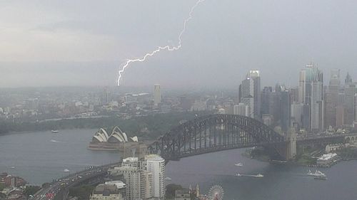
Sudden storm hits Sydney
A snap storm caused delays at Sydney Airport this afternoon which left about a dozen planes unable to land.
Pilots circled the airport as they waited for the storm to pass.
Flights have since returned to normal.
A strong north-easterly storm hit the city’s south and south-west the hardest.
The weather system brought heavy rain and gusts of 80km/h were felt in Penrith.
While the thunderstorms in NSW have eased, the bureau said they could redevelop.
A severe weather warning was in place tonight for central and northern parts of NSW.

BoM meteorologist Angus Hines said severe thunderstorms had been most likely to occur in parts of Queensland today.
“This is not only where severe thunderstorms are most likely to occur today, but this is where we could see even more significant weather impacts in the form of giant hailstones, potentially five centimetres or greater, and destructive winds 120km/h or stronger,” Hines said.
“The region where we could see those really high-end impacts goes from western parts of Brisbane and the Sunshine Coast up into the hinterlands, across Toowoomba, into the Darling Downs then across the southern border ranges and into the north-western slopes of NSW.”