
Share this @internewscast.com
Hurricane Imelda has taken a shocking turn, sparing the southeastern US from the landfall meteorologists had previously feared.
The alteration in Imelda’s path is attributed to an uncommon interaction with Hurricane Humberto and a high-pressure system emerging over the Northeast, which is directing Hurricane Imelda into the ocean.
Imelda, which escalated into a Category 1 hurricane on Tuesday with winds peaking at 85 mph, is primarily skirting the coastline. Nonetheless, the risks of perilous rip currents, turbulent waves, and spot flooding still linger.
Experts explain that this unexpected change is a result of the Fujiwhara Effect, where two storms in close proximity ‘orbit’ around one another, consequently affecting each other’s course.
For a time, Humberto and Imelda were less than 500 miles apart, close enough for significant interaction.
Instead of slamming into the Carolinas or Georgia, Imelda is now being tugged northeastward as Humberto curves off to the open Atlantic.
However, swells from Imelda and the more distant Hurricane Humberto are hitting the Bahamas and spreading along the US East Coast.
‘These swells are likely to cause life-threatening surf and rip current conditions,’ forecasters said.

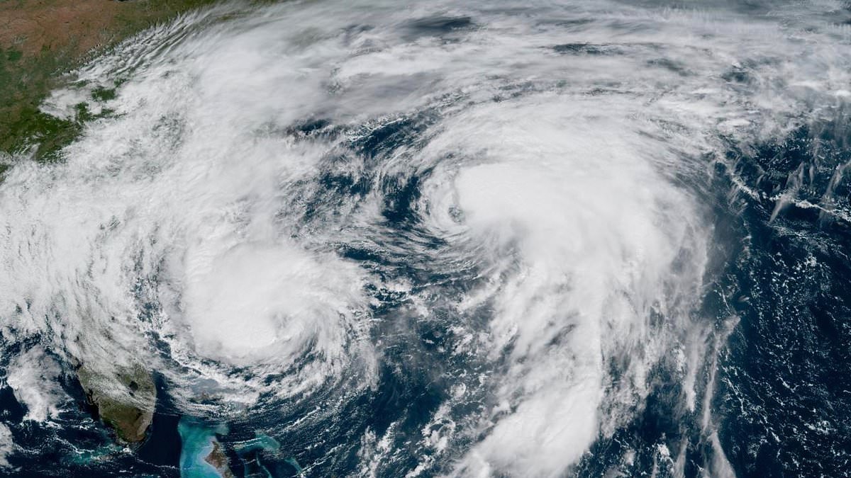
The Atlantic hosts two hurricanes, Imelda on the left and Humberto on the right, showcasing a unique ‘dance’. This occurrence is identified as the Fujiwhara Effect.

The two hurricanes are nearly 500 miles apart as they churn through the Atlantic Ocean
If Imelda had landed and lingered over the Southeast, it might have unleashed torrential rain on riverine and coastal zones, potentially surpassing the flooding instigated by Hurricane Matthew back in 2016.
However, AccuWeather meteorologists are continuing to monitor the region extending from Florida to the southwestern Gulf and the western Caribbean for any tropical developments in the forthcoming weeks.
‘The danger is that quick tropical development in these areas would give little time to prepare should a tropical storm or powerful hurricane evolve,’ they said.
Satellite images show that Imelda is becoming more organized, with a rough eye and strong thunderstorms, as it sits about 400 miles southwest of Bermuda.
The National Hurricane Center (NHC) said in a Wednesday update that the hurricane’s center should pass near Bermuda this afternoon or evening and move away by Thursday afternoon.
The hurricane is expected to strengthen to near Category 2 strength when it passes close to the island. Over the next few days, Imelda will weaken and turn into an extratropical storm.
Swells from both Hurricane Imelda and Hurricane Humberto are already affecting the Bahamas, Bermuda, and much of the US East Coast.
These large waves can create dangerous surf and strong rip currents. People in these areas should follow guidance from their local weather offices, the NHC warned.

Hurricanes Imelda and Humberto are projected to cause a high risk of heavy rain and wind throughout the Southeast this week

Hurricane Imelda (pictured) reached Category 1 status Tuesday morning, with sustained winds of 75 mph
The outer bands of distant Hurricane Humberto lashed Bermuda on Tuesday ahead of a more direct pass from the newer and stronger Hurricane Imelda on the tiny British territory.
Humberto was passing well north of the island in the north Atlantic, but wind gusts and some rain were forecast into Wednesday.
A hurricane warning for Bermuda was in effect ahead of Imelda, which was expected to strengthen into a Category 2 hurricane, according to the Bermuda Weather Service.
Michael Weeks, Bermuda’s minister of national security, said: ‘I cannot overstate the seriousness of this threat. This is not, I must stress, a passing squall.’
He said Bermuda would endure sustained hurricane-force winds for up to six hours starting late Wednesday.
The island’s international airport, schools and government offices were to close on Wednesday, and Weeks said residents should have all storm preparations completed by noon.
While the threat from Imelda and Humberto is expected to fade over the next week, forecasters have warned that it’s too early to let your guard down.
The US is currently in the historic peak of hurricane season, which traditionally lasts from September 10 through the middle of October.
AccuWeather senior meteorologist Chad Merrill has been tracking this double hurricane and told the Daily Mail more could still be on the way.

‘We’ll probably see a couple of more storms develop between now and the end of the hurricane season,’ Merrill said.
‘We’ll probably see a couple of more in October as well. So, people need to be on guard all the way through the end of the hurricane season,’ the 22-year veteran forecaster added.
Imelda became the fourth hurricane of the 2025 Atlantic season, which is still below the pace predicted by the National Oceanic and Atmospheric Administration (NOAA) this spring.
NOAA experts warned that 2025 could end up producing more named storms than the US East Coast saw last year, when there were 18 named weather events.
With two months to go in hurricane season, Imelda is only the ninth named storm to form in the Atlantic.
While none of the four hurricanes to this point have made landfall in the US, this season has already been historic, with both Hurricanes Erin and Humberto reaching Category 5, the most severe level of tropical cyclone.
According to Matt Devitt of WINK News in Southwest Florida, it’s the first time in over 90 years that there have been multiple Category 5 storms in back-to-back years during the Atlantic hurricane season.