
Share this @internewscast.com
La Nina weather patterns are increasingly likely to influence large parts of Australia by the year’s end due to updated forecasting models.
Climate change and rapid ocean warming have prompted the Bureau of Meteorology to update its analysis methods for El Nino and La Nina patterns.
The former brings warmer conditions while La Nina leads to increased cloud and rain.
Both weather patterns are influenced by sea temperatures in the tropical Pacific Ocean.
The forecasters have adopted a new approach, the relative Niño index, to better account for rising sea temperatures in their predictions.
It says without the shake-up, El Nino may seem more frequent and La Nina may appear less common.
Aside from weather forecasting afficionados, most Australians will be more interested in what it means for our approaching summer weather.
The answer is La Nina is more likely based on the relative index, which is in line with current seasonal outlooks.
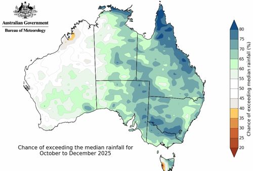
They forecast above average over large areas of Australia’s north and east during the last three months of this year.
Daytime temperatures may also dip across these regions during late spring into early summer because of the increased cloud cover.