
Share this @internewscast.com
Hurricane Melissa struck the Caribbean on Monday afternoon, marking its arrival as a potentially historic and devastating event.
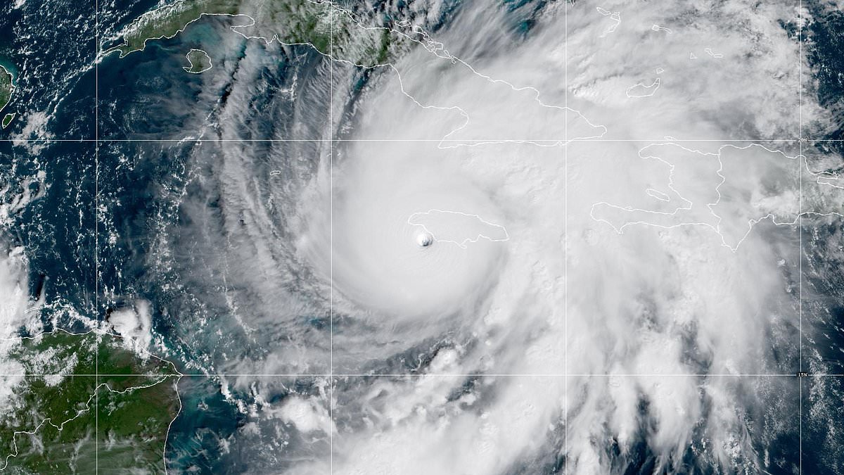
Classified as a Category 5 hurricane, Melissa has been dubbed the ‘storm of the century’ and has surpassed the intensity of Hurricane Katrina. The storm is set to wreak havoc across Jamaica, bringing with it severe flooding and ferocious winds reaching speeds of 185 mph.
The hurricane’s eye is encircled by the fierce winds of the eyewall, a sign of its formidable power.
According to the National Hurricane Center, these intense winds advanced towards Jamaica before the storm made landfall around 1 p.m. near New Hope.
Jamaican officials have cautioned residents against underestimating the storm, emphasizing that failing to take precautions could be life-threatening.
Having intensified to its peak strength on Monday, Hurricane Melissa has already begun battering the coast with perilous winds and waves, posing significant threats to life and property.
Meteorologists confirmed Melissa was now more intense than Katrina, which caused an estimated $125bn (£94bn) worth of damage and killed 1,392 people when it hit New Orleans in 2005.
Melissa is one of the fiercest hurricanes to make landfall in the Atlantic basic. Only two other storms, 2019’s Dorian and the Labor Day hurricane in 1935, did that in the past.

Hurricane Melissa made landfall across the Caribbean Monday afternoon as the terrifying storm is set to be the worst in history. The eye of the storm is currently surrounded by the powerful winds

People are seen swimming in the water as Hurricane Melissa approached Kingston, Jamaica on Tuesday
Dorian also had winds of 185pmh when it ravaged the Abaco Islands in the Bahamas.
Jamaica has not been hit with such an intense hurricane since 1988 when Gilbert made landfall.
That hurricane was a Category 4 that hit west of Kingston.
Melissa is not expected to make landfall in the US, but forecasters have warned of rough surf as the storm moves along the East Coast.
The storm is moving slowly north-northeastward, according to the National Hurricane Center.
‘Over the next several days, the hurricane is expected to accelerate to the northeast within the flow ahead of an amplifying trough over the southeastern US,’ the agency said.
‘This steering flow will bring the core of Melissa across Jamaica today, over eastern Cuba early Wednesday, and across the southeastern or central Bahamas later on Wednesday.
‘Then, the hurricane is forecast to pass near Bermuda Thursday night or early Friday.’
American mother, Kristin Morgan, told CNN she has been stranded at her hotel in Lucea, close to Montego Bay.
‘I’m just feeling like I’d like to get home to my children,’ she said, noting she is visiting Jamaican for a wedding while her children are with a grandparent in Atlanta.

A partially collapsed hoarding frame near the Digicel Delves Building is seen in downtown Kingston

Vicious wind is seen splashing water around and blowing palm trees in Kingston
‘There were no flights available until Friday 31 and then slowly flights would open up. They’ve been opening and then being canceled as well. It’s been a hot potato situation.’
She said the hotel staff has been working diligently to keep guests informed as the storm develops.
‘They’ve been trying to communicate as much as they can while the phones are still working,’ Morgan said.
‘The waters are choppy. It’s a gray blast outside. The wind is just out of control. There is no sign of life whatsoever outside.’
Meanwhile, Florida has been hit with 20 inches of rain that swept across parts of the Sunshine State Sunday night and into Monday triggering flash floods.
The slow-moving storm system was declared by the National Weather Service (NWS) as a ‘particularly dangerous situation’.
Pictures and videos emerged on social media of the four-star resort The Boca Raton, in Boca Raton, being swamped with flood waters.
Murky waters entered the lobby of the luxury hotel flooding it, with patio furniture strewn across the interior, as staff had to resort to wading through it.
Images also emerged of streets in Mount Dora, in the center of the state, having been completely washed away as a result of the torrential downpours.

Meanwhile, Florida has been hit with 20 inches of rain that swept across parts of the Sunshine State. Pictures and videos emerged on social media of the four-star resort The Boca Raton, in Boca Raton, being swamped with flood waters

A washed out section of Donnelly Street in Mount Dora is seen here on Monday after downpours flooded the area with nearly 20 inches of rain

Mount Dora was hit with as much as 17.8 inches of rain, with nearby Eustis receiving 19.7 inches within a 24-hour period.
The area was hit with as much as 17.8 inches of rain, with nearby Eustis receiving 19.7 inches within a 24-hour period.
Zach Law, a meteorologist with the NWS, told ABC News that parts of the state hadn’t seen such levels since Hurricane Ian in 2022.
A spokesperson for The Boca Raton said that the area was cleared out to dry and the hotel is back operating as normal with no impact to guests.
Most of the standing water in Boca Raton receded by Monday after the city’s storm-water management system was able to catch up, officials said.
Some areas in the southeast parts were still dealing with standing water into Monday afternoon, there were no reports of any significant damage to homes.
According to the local police department, as many as 100 cars were towed after being abandoned on Sunday night.
The Boca Raton Airport had to temporarily close due to severe flooding before it was reopened on Monday.
After the deluge that hit the state earlier this week, forecasters said that ‘fall-like weather’ was now on the way with a settled outlook.