
Share this @internewscast.com
The Storm Team 11 forecast predicts mostly cloudy conditions with a 50% chance of scattered showers and possibly a few thunderstorms, which will be more isolated as the night progresses. Additionally, late-night patchy fog is possible. The temperature will drop to a low of 60 degrees.
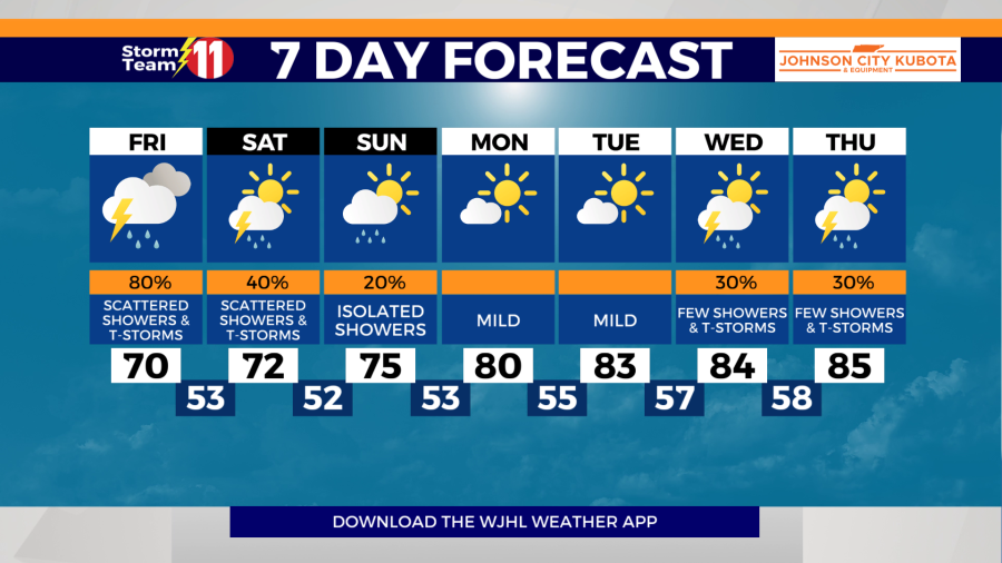
Friday’s weather will end the week on a wet note, with an 80% probability of scattered showers and thunderstorms. Some storms might be stronger, particularly in the afternoon, primarily posing risks of damaging winds and hail. Temperatures will peak around 70 degrees. Scattered showers and thunderstorms are expected to persist into Friday night, with temperatures falling to a low of 52 degrees.
Saturday afternoon and evening will see more scattered showers and thunderstorms, with a high temperature of 72 degrees and a 40% chance of rain. The night will be partly cloudy, with temperatures dropping to a low of 48 degrees.
Sunday will be partly cloudy with a 20% chance of isolated showers. The high will be 75 degrees. Sunday night will be partly cloudy with a low of 50 degrees.
Monday, we will start to warm back to near seasonal highs under partly cloudy skies. The high will be 80 degrees. Monday night will be clear with a low of 55 degrees.
We continue the warm-up into Tuesday with a high near 83 degrees. Tuesday night will be partly cloudy with a low of 58 degrees.
Wednesday will be partly cloudy with a 30% chance of scattered showers and thunderstorms. The high will be even warmer with a high of 84 degrees.
A few showers and thunderstorms are possible once again into next Thursday. The high will be around 85 degrees.
Have a great night and stay dry.