Share this @internewscast.com
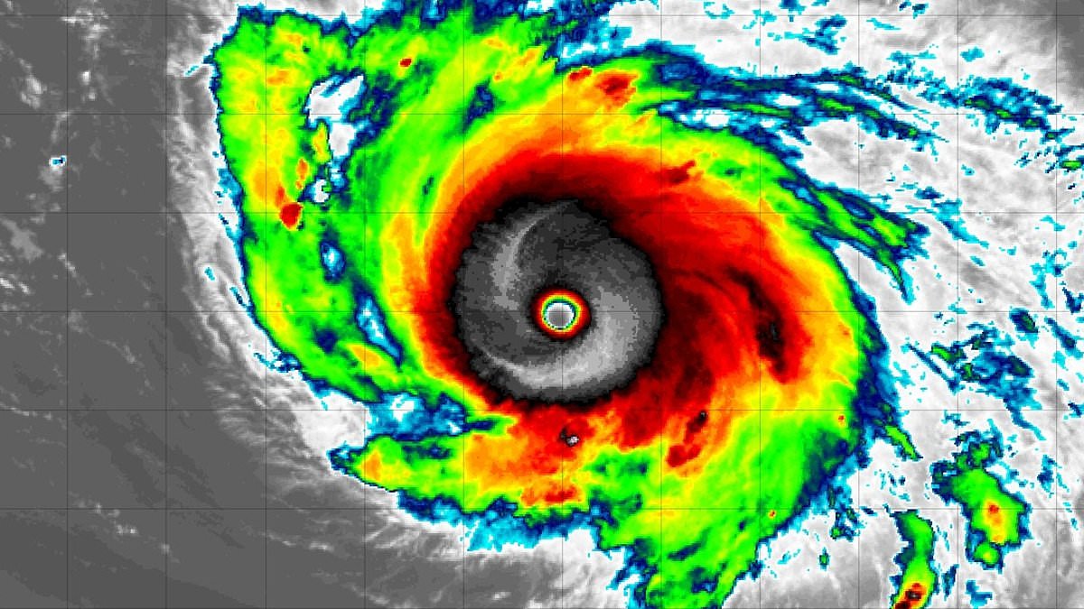
Hurricane Humberto has become a Category 5 storm with devastating winds reaching 160 mph as it nears the East Coast.
The National Hurricane Center (NHC) reported that a major storm intensified to the most severe category of a tropical cyclone by Saturday afternoon, accelerating by over 50 mph within just a day.
Humberto is anticipated to remain a significant hurricane until Tuesday, at which point it is forecasted to approach its nearest proximity to the US. This could result in powerful surf, flooding, and hazardous rip currents along the East Coast beaches.
Humberto’s sustained winds of 160 mph are deemed ‘catastrophic,’ with the potential to cause significant harm to structures, infrastructure, and the environment even if the storm stays offshore.
Matt Devitt from WINK News in Southwest Florida highlighted that this marks the first occurrence in 92 years of multiple Category 5 hurricanes occurring in consecutive years during the Atlantic hurricane season.
Humberto joined Hurricane Erin, which also did not make landfall this summer, but did brings coastal flooding to the mid-Atlantic.
However, forecasters are more concerned with another storm system now feared to strengthen into a hurricane right over the US mainland.
NHC has been tracking Tropical Depression Nine, which they believe will turn into Tropical Storm Imelda by Sunday.

Hurricane Humberto (pictured) strengthened into a Category 5 storm on Saturday afternoon

Tropical Depression Nine, which would be named Imelda when it becomes a tropical storm, is projected to threaten the Southeast next week
On Saturday morning, ‘Imelda’ evolved into a tropical depression, which is the initial stage of a tropical cyclone. This stage is characterized by a low-pressure zone with thunderstorms and relatively minor winds.
Currently forming near the coast of Cuba with 35 mph sustained winds, meteorologists expect this storm to travel northward along the East Coast, affecting Florida, Georgia, and the Carolinas.
The latest forecast from NHC officials warn that Imelda will turn into a hurricane right as it approaches the Georgia and South Carolina coasts.
‘I can’t rule out a hurricane at landfall along with significant flooding as it could slow down or even stall,’ Devitt warned in a post on X on Friday.
Current spaghetti models for the storm show Imelda is expected to reach the Southeast coast and then join Hurricane Humberto out in the Atlantic, turning away from land at the land moment.
However, some storm tracks warn that a hurricane landfall in either Florida or Georgia is still a possibility.
A spaghetti model shows the different possible paths a tropical storm or hurricane might take, based on predictions from multiple weather computer programs.
Each line represents one model’s guess about where the storm could go. If the lines are close together, it means most models agree on the path, and the prediction is more certain.

Storm tracks show Imelda may make landfall at multiple points along the East Coast, from Florida to the Carolinas

Hurricane Humberto is projected to remain at sea and not make landfall in the US
Currently, meteorologists do not expect Hurricane Humberto to reach the US coastline, adding it will eventually turn out to sea like Hurricane Gabrielle did earlier in September.
Meanwhile, AccuWeather senior meteorologist Chad Merrill told the Daily Mail that Imelda’s ‘legacy will be flooding.’
The veteran forecaster predicted that Imelda could severely impact the Carolinas next week, bringing ‘heavy rain and severe flooding’ to areas ravaged by Hurricane Helene a year ago.
Moreover, hurricane forecasters have been bracing for a potential Fujiwhara Effect, which takes place when two major cyclones get so close to each other that they start to interact.
The storms might rotate around a common point between them, like two hurricanes doing a slow dance.
In some cases, a stronger storm, like Humberto, might absorb a weaker one, creating an even more massive weather event than either storm would have been on their own.
If they’re similar in size and strength, however, they might repel each other and get thrown in completely different directions that forecasters won’t be able to project beforehand.