Share this @internewscast.com
Emergency officials are advising people in Alaska’s capital, Juneau, to evacuate due to glacial flooding from the Mendenhall River, which poses a threat to the city.
Authorities have suggested that residents in the areas susceptible to 17-foot lake level flooding should vacate until the water subsides and an ‘All Clear’ notification is issued through the wireless emergency alert system.
In a Facebook update, officials reported a glacial outburst at Suicide Basin. This basin is held by the Mendenhall Glacier, which has been melting and retreating rapidly, mainly due to climate change.
‘The basin is releasing, and flooding is expected along Mendenhall Lake and River late Tuesday through Wednesday,’ they added.
The river is expected to crest around 4pm local time (8pm ET) on August 13.
Authorities are now racing against the clock to protect Mendenhall Valley, where most of Juneau’s 32,000 residents live.
They are relying on two miles of emergency flood barriers installed just last month, though officials warn the swelling waters could overwhelm them.
A sizeable glacial outburst can unleash as much as 15 billion gallons of water, similar to approximately 23,000 Olympic-sized swimming pools, as stated by the University of Alaska Southeast and the Alaska Climate Adaptation Science Center.
Nicole Ferrin, a National Weather Service (NWS) meteorologist, stated: ‘This will set a new record, according to all available data.’

Flooding is commencing in this Alaskan city amid fears of a historically high water surge. Authorities are in a race against time to safeguard Mendenhall Valley, where the majority of Juneau’s 32,000 residents live.

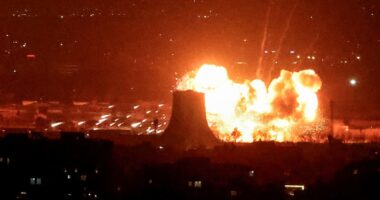
Officials said a glacial outburst has occurred at Suicide Basin (pictured)
At 3:30am Wednesday, Mendenhall Lake’s stage was 15.3 feet and rising, already within major flood stage, which begins at nine feet.
Forecasts predict a record crest between 16.25 and 16.75 feet is expected between 8am and 12pm, with increasing confidence that the river will peak near 16.75 feet around 8am.
Water levels are expected to drop below the major flood stage by Wednesday night.
The NWS said that as water levels rise, flooding will progressively impact homes, roads and riverbanks along View Drive, Meander Way, River Road, and surrounding areas.
Low-lying yards and backyards will begin to flood at around 11 feet, with roads becoming impassable and bank erosion increasing as levels climb.
By 15 to 16 feet, multiple homes, intersections, and parts of Riverside Drive will experience major flooding, and by 17 feet, entire neighborhoods, including homes on Meadow Lane, businesses near Vintage Park Boulevard, and all of View Drive, could be inundated, with streets submerged and riverbanks overtopped.
A glacial lake outburst flood (GLOF) is very different from typical flooding caused by heavy rain or storms.
According to the US Geological Survey (USGS), glacial lakes form in small side valleys that have lost ice and become blocked by the main glacier or by natural rock and debris.

The Mendenhall Glacier is about 12 miles from Juneau, which is home to around 32,000 people. The city is also a popular tourist destination

Residents received text alerts warning about the impending flooding
Over time, these ice-free basins fill with water until the pressure becomes too great.
The USGS explains that when the water forces a path beneath the glacier, it can suddenly release downstream, triggering a GLOF.
‘These events are unpredictable and have caused significant loss of life and infrastructure worldwide,’ the USGS said.
‘Furthermore, it is unclear how these lake hazards may change as temperatures rise and glaciers continue to melt.’
Many roads, including Mendenhall Loop Road, have been closed, along with facilities along the Mendenhall Valley Public Library, Diamond Park Field House, Diamond Park Aquatic Center and fields located along the river.
‘The closure will remain in effect until water levels recede below 12 feet and bridge engineers complete a safety inspection,’ officials said.

The FAA is banning flights near a large portion of the the Mendenhall River until next week
A Red Cross shelter was set up for residents at Floyd Dryden Gymnasium.
The Federal Aviation Administration (FAA) has also issued a Temporary Flight Restriction (TFR) over a portion of the Mendenhall River until 8pm on August 19.
‘No flights, including drones, are allowed in the TFR zone from the surface up to and including 400 feet AGL unless authorized by the Incident Commander and FAA Air Traffic Control,’ the alert reads.
The Mendenhall Glacier is about 12 miles from Juneau and is a popular tourist attraction due to its proximity to Alaska’s capital city and easy access on walking trails.
The only trails currently open are the Trail of Time and East Glacier. All other lake level trails, including Nugget Falls, Photo Point, and Moraine Ecology, are closed until further notice.
Homes on the city’s outskirts are within miles of Mendenhall Lake, which sits below the glacier, and many front the Mendenhall River.

Juneau experienced consecutive years of record flooding in 2023 (pictured) and 2024
Flooding from the basin has been an annual concern since 2011, and in recent years, it has swept away houses and inundated hundreds of homes.
This year, government agencies installed temporary barriers in an effort to protect several hundred homes in the inundation zone from widespread damage.
The flooding occurs because a smaller glacier near the Mendenhall Glacier has retreated, a consequence of warming temperatures, leaving a basin that fills with rainwater and snowmelt each spring and summer.
When the water builds enough pressure, it forces its way under or around the ice dam formed by the Mendenhall Glacier, spilling into Mendenhall Lake and eventually the Mendenhall River, as it did Tuesday.
Before the basin reached its capacity and began overtopping, water levels were rising rapidly, up to four feet per day on especially sunny or rainy days, according to the NWS.
Juneau experienced consecutive years of record flooding in 2023 and 2024.
Last August, the river crested at 15.99 feet, about one foot above the previous record, with flooding spreading farther into Mendenhall Valley. This year, officials predicted the river would crest between 16.3 and 16.8 feet.