
Share this @internewscast.com
Fifth time’s the charm? After an early summer lull, the Atlantic could soon have its first hurricane of the year: Erin.
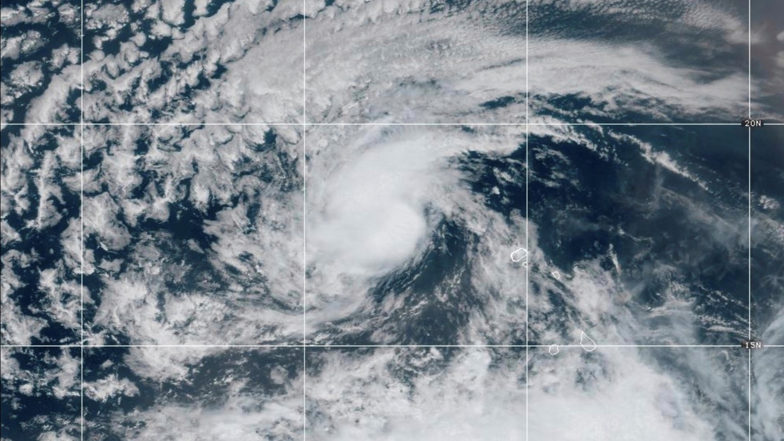
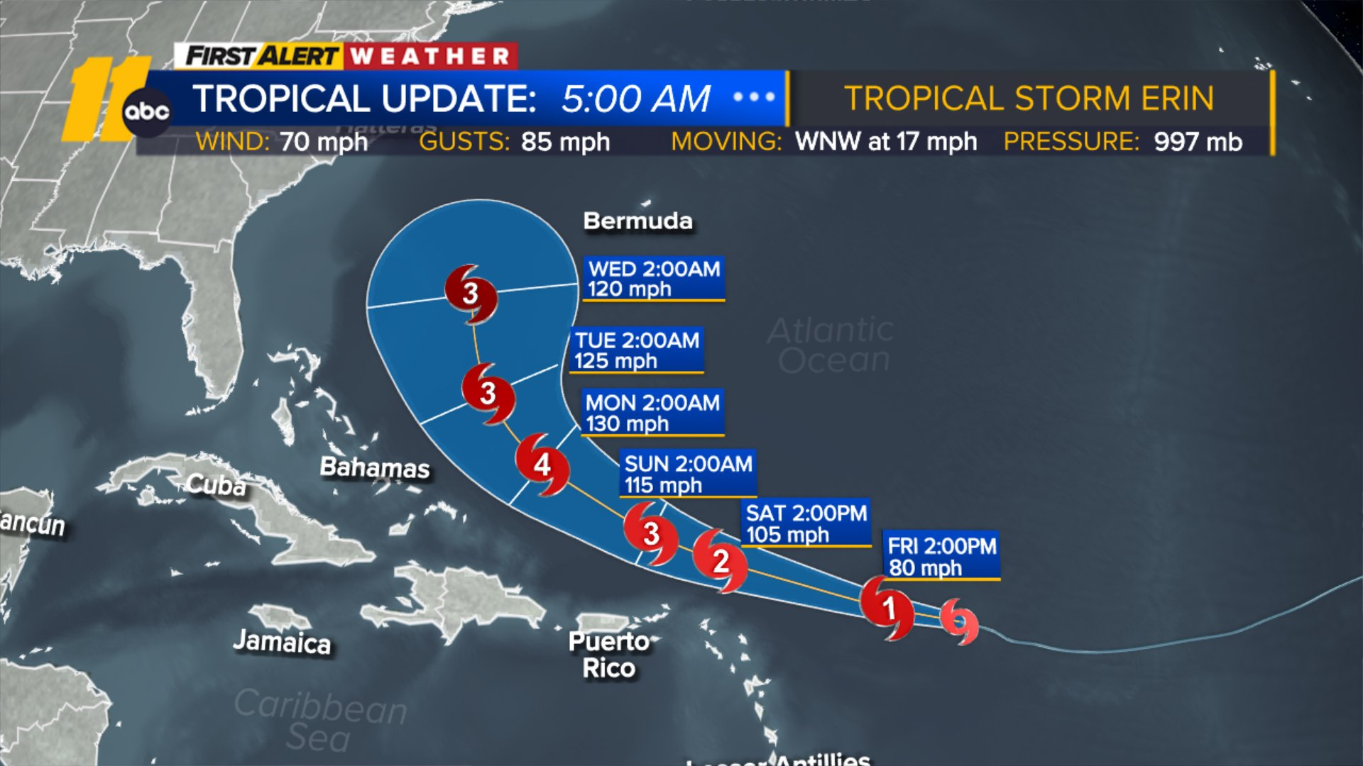
Erin strengthened into a strong tropical storm with sustained winds of 70 mph on Thursday evening while over the open tropical Atlantic, according to the National Hurricane Center.
The storm could bring some gusty winds, rain, rough surf and rip currents to parts of the far northeastern Caribbean as it slides just north of the islands this weekend.
Erin is tracking west-northwest on Friday morning, still hundreds of miles away from any land. The storm is expected to strengthen over the next few days as it cruises across the Atlantic and is expected to become a Category 4 hurricane by Sunday.
Four other systems roamed the Atlantic basin before Erin – Andrea, Barry, Chantal and Dexter – but none were stronger than a tropical storm.
The season’s first hurricane is slightly behind schedule. The first hurricane of the season typically forms around August 11, although recent seasons have had some early arrivals. There had already been three hurricanes – Beryl, Debby and Ernesto – at this point last year.
Erin is forecast to pass just north of the Leeward Islands, the Virgin Islands and Puerto Rico this weekend, while making a gradual turn toward the north. Tropical storm watches were issued for several of the northern Leeward Islands on Thursday evening.
Direct landfall on any of the Caribbean islands is unlikely, but not impossible, if Erin’s path wobbles in the coming days.
It’s more likely that Erin will churn up rough seas and produce rip currents in the Caribbean through the weekend and into early next week. Gusty wind and rain – which could be heavy at times – are also possible depending on exactly how close Erin tracks to the islands. The storm’s intense rain could also cause flash flooding or mudslides.
It’s too soon to know what kind of threat Erin could pose to Bermuda. Any potential impacts to the island should become clearer early next week. The hurricane is currently forecast to stay away from the United States, but that’s not an absolute certainty. Even if it does remain offshore, Erin could also generate rough surf and dangerous rip currents along the US East Coast next week.
Erin’s track could depend on this factor
How quickly Erin strengthens in the coming days could be the key factor in its eventual path.
There’s plenty of fuel for Erin to tap into in the western Atlantic as sea surface temperatures are much warmer than normal. They aren’t quite as warm as the record levels reached in 2023 and 2024, but are still far warmer than they’d be in a world that wasn’t heating up due to fossil fuel pollution.
Erin could explode in strength once it reaches this very warm water and become the season’s first major hurricane – Category 3 or higher – by Sunday, according to the National Hurricane Center.
When hurricanes grow stronger, their storm clouds also grow taller and reach higher into the atmosphere. That extra height allows them to tap into the faster winds present higher in the atmosphere that can pull the storm more to the north.
The Bermuda High – a large, semi-permanent area of clockwise circulating high pressure that meanders over the Atlantic Ocean – is often in the driver’s seat in this case: When the high turns the steering wheel, the hurricane generally follows.
But if Erin develops more slowly, the system could stay lower in the atmosphere, where the trade winds – winds that flow clockwise around the equator – could keep it tracking to the west and prevent it from turning.
Which scenario wins out will become clear by the weekend, but any islands in the potential path of Erin should prepare ahead of time.
Other potential tropical trouble
August is when the tropics usually come alive: The busiest stretch of the season typically spans from mid-August to mid-October. Forecasters expect above-average tropical activity this year and more storms could form in short order.
An area of showers and thunderstorms in the southern portion of the Gulf has a medium chance of becoming a tropical depression before the weekend, according to the National Hurricane Center.
The stormy area has a short window to develop while drifting over the very warm water of the Gulf before it moves inland, likely in northeastern Mexico or southern Texas, by Friday night.
Periods of heavy rain are possible in the area Friday regardless of whether a tropical depression or tropical storm forms. A Level 2 of 4 risk of flooding rain is in place Friday in far southern Texas with a Level 1 of 4 risk for the rest of the state’s Gulf Coast, as well as parts of southern Louisiana, due to the anticipated arrival of moisture-loaded air, according to the Weather Prediction Center.
The rain could result in some flooding, especially along low-lying or poor drainage areas, according to the National Weather Service in Brownsville, Texas.
Featured video is from a previous report.