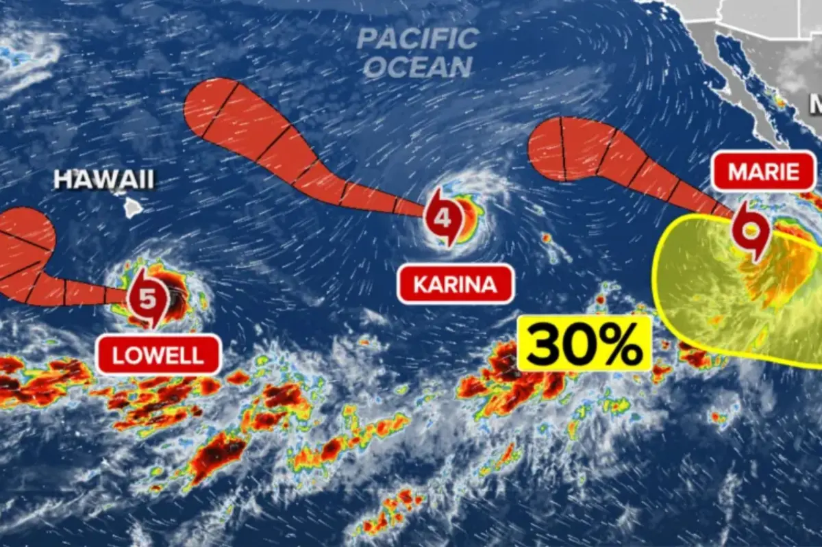

Hurricane Lowell has surged into a formidable Category 5 storm, adding to an increasingly active Pacific hurricane basin where several tropical systems are being watched for possible impacts to Hawaii by the weekend.
Forecasters are currently focused on two powerful storms in the Central Pacific: newly intensified Category 5 Hurricane Lowell and Category 4 Hurricane Karina, both of which are churning over warm ocean waters.
“There are no immediate threats, but that could certainly change,” the FOX Forecast Center said.
Lowell reached major hurricane status late Tuesday after first becoming a hurricane early that morning, then rapidly strengthening overnight. By Wednesday evening, the National Hurricane Center confirmed Lowell had intensified into a Category 5 hurricane.
Farther east, Tropical Storm Marie continues to rotate off Mexico’s coast, while the National Hurricane Center is also tracking another nearby disturbance with a low chance of development.
The burst of tropical activity comes as an ongoing El Niño pattern helps create conditions favorable for storm formation and strengthening across the Pacific.
Hawaii monitoring complicated future of Karina and Lowell
Karina, now a Category 4 hurricane, is still gaining strength over the open eastern Pacific, while Lowell remains an exceptionally intense Category 5 system farther west.
Both hurricanes are moving generally west, and forecasters are closely watching whether the two major systems could influence each other’s paths or intensity in the days ahead.
Karina is currently being steered west by high pressure to its north. If this northern ridge strengthens, there is a chance it could force a slightly more southerly track toward Hawaii way down the line.
Meanwhile, Lowell should maintain a westward path through the next couple of days, held on course by high pressure established to its north.
Beyond that, the forecast becomes more complicated, with model guidance showing increasing disagreement on exactly when — and how sharply — the storm will turn west-northwest.
Part of that uncertainty is tied directly to Hurricane Karina to the northeast, which could influence Lowell’s steering pattern later in the forecast.
A closer interaction with the larger Karina could disrupt Lowell’s environment and cap its development. Conversely, a greater separation would allow Lowell to take better advantage of otherwise favorable conditions.
For now, Lowell is projected to track south of Hawaii before likely making a larger turn to the north, but the long-range future holds too many variables to provide clearer details.
Hurricane Lowell is the first Category 5 storm in the Central Pacific basin since Hurricane Walaka in October 2018, according to NOAA.
Tropical Storm Marie forms in Eastern Pacific
Tropical Storm Marie continues to churn off the southwest Mexican coast, with environmental conditions conducive for continued growth and further development.
The FOX Forecast Center is monitoring whether moisture from newly formed Tropical Storm Marie will track into California early next week.
As Marie pulls northward through the end of the week, it will pump additional tropical moisture to the region, prompting a Level 2 out of 4 flash flood risk across southern Arizona on Friday, including Phoenix and Tucson.
A new area to watch
Off the coast of southwestern Mexico, near where Tropical Storm Marie is moving, the NHC has highlighted a new area to watch.
The NHC warned that an area of low pressure could form over the weekend, with gradual development possible as early as next week as the system moves off the coast of Mexico.
The area has a 20% chance of development over the next seven days, and a near-zero chance to develop over the next two days, according to the NHC.